
 Puerto de la Duquesa
La Serna de Iguña
Pumalverde
Puentenansa
La Iglesia
Casar de Periedo
Fuengirola
Renedo de Piélagos
Villabanez
Puerto de la Duquesa
La Serna de Iguña
Pumalverde
Puentenansa
La Iglesia
Casar de Periedo
Fuengirola
Renedo de Piélagos
Villabanez
Parque de El Baldio on the map, Santa Marta de Tormes, Spain
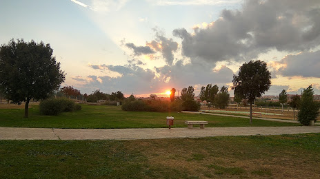
Photo
Where is located Parque de El Baldio
Parque de El Baldio — local attraction, which is located at 37003 Salamanca, Spain and belongs to the category — park. Average visitor rating for this place — 4.4 (according to 199 ratings, information from open sources and relevant for 2022).
Exact location — Parque de El Baldio, marked on the map with a red marker.
You can get directions to Parque de El Baldio on the map from your location.
What else is interesting in Santa Marta de Tormes? You can see all the sights if you go to the city page.
Coordinates
Parque de El Baldio, Spain coordinates in decimal format: latitude — 40.962926481622425, longitude — -5.6409754375099865. When converted to degrees, minutes, seconds Parque de El Baldio has the following coordinates: 40°57′46.54 north latitude and -5°38′27.51 east longitude.
Nearby cities
The largest cities that are located nearby:
- Salamanca — 4 km
- Valladolid — 108 km
- Móstoles — 164 km
- Alcorcón — 166 km
- Fuenlabrada — 170 km
- Leganés — 171 km
- Alcobendas — 173 km
- Getafe — 175 km
- León — 182 km
- Torrejón de Ardoz — 189 km
- Alcala de Henares — 197 km
- Burgos — 221 km
- Ourense — 239 km
- Braga
 (Portugal) — 241 km
 - Coimbra (Portugal) — 249 km
- Porto (Portugal) — 251 km
- Badajoz — 256 km
- Oviedo — 267 km
- Gijón — 286 km
Distance to the capital
Distance to the capital (Madrid) is about — 174 km.