
 Puerto de la Duquesa
La Serna de Iguña
Pumalverde
Puentenansa
La Iglesia
Casar de Periedo
Fuengirola
Renedo de Piélagos
Villabanez
Puerto de la Duquesa
La Serna de Iguña
Pumalverde
Puentenansa
La Iglesia
Casar de Periedo
Fuengirola
Renedo de Piélagos
Villabanez
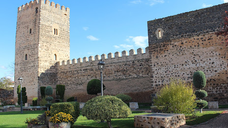
Castillo de Doña Berenguela on the map, Bolaños de Calatrava, Spain
Photo
Where is located Castillo de Doña Berenguela
Castillo de Doña Berenguela — local attraction, which is located at C. Altozano, 4, 13260 Bolaños de Calatrava, Cdad. Real, Spain and belongs to the category — castle. Average visitor rating for this place — 4.3 (according to 482 ratings, information from open sources and relevant for 2022).
Exact location — Castillo de Doña Berenguela, marked on the map with a red marker.
You can get directions to Castillo de Doña Berenguela on the map from your location.
What else is interesting in Bolaños de Calatrava? You can see all the sights if you go to the city page.
Coordinates
Castillo de Doña Berenguela, Spain coordinates in decimal format: latitude — 38.90618758209757, longitude — -3.6643065679777904. When converted to degrees, minutes, seconds Castillo de Doña Berenguela has the following coordinates: 38°54′22.28 north latitude and -3°39′51.5 east longitude.
Nearby cities
The largest cities that are located nearby:
- Jaén — 125 km
- Córdoba — 149 km
- Fuenlabrada — 153 km
- Getafe — 155 km
- Albacete — 156 km
- Móstoles — 158 km
- Leganés — 158 km
- Alcorcón — 160 km
- Torrejón de Ardoz — 172 km
- Alcala de Henares — 176 km
- Alcobendas — 180 km
- Granada — 191 km
- Murcia — 243 km
- Málaga — 251 km
- Almería — 253 km
- Dos Hermanas — 268 km
- Cartagena — 273 km
- Salamanca — 283 km
- Badajoz — 285 km
Distance to the capital
Distance to the capital (Madrid) is about — 168 km.