 Betteshanger
Lynton
Amesbury
Marlow
Burford
Chipping Norton
Marlborough
Cairnryan
Lydney
Betteshanger
Lynton
Amesbury
Marlow
Burford
Chipping Norton
Marlborough
Cairnryan
Lydney
Winchester Science Centre & Planetarium on the map, Winchester, United Kingdom
Photo
Where is located Winchester Science Centre & Planetarium
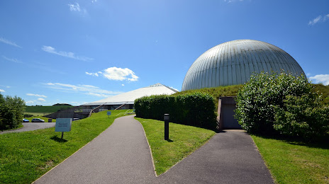
Winchester Science Centre & Planetarium — local attraction, which is located at Telegraph Way, Winchester SO21 1HZ, United Kingdom and belongs to the category — planetarium. Average visitor rating for this place — 4.0 (according to 248 ratings, information from open sources and relevant for 2022).
Exact location — Winchester Science Centre & Planetarium, marked on the map with a red marker.
You can get directions to Winchester Science Centre & Planetarium on the map from your location.
What else is interesting in Winchester? You can see all the sights if you go to the city page.
Coordinates
Winchester Science Centre & Planetarium, United Kingdom coordinates in decimal format: latitude — 51.05937486342068, longitude — -1.2653910747915944. When converted to degrees, minutes, seconds Winchester Science Centre & Planetarium has the following coordinates: 51°3′33.75 north latitude and -1°15′55.41 east longitude.
Nearby cities
The largest cities that are located nearby:
- Southampton — 18 km
- Portsmouth — 31 km
- Reading — 49 km
- Bournemouth — 55 km
- Swindon — 64 km
- Slough — 70 km
- Oxford — 77 km
- Crawley — 78 km
- Sutton — 84 km
- Watford — 91 km
- Bristol — 98 km
- Cheltenham — 107 km
- Luton — 109 km
- Eastbourne — 116 km
- Northampton — 133 km
- Gillingham — 133 km
- Basildon — 136 km
- Worcester — 140 km
- Chelmsford — 143 km
Distance to the capital
Distance to the capital (London) is about — 94 km.