 Betteshanger
Lynton
Amesbury
Marlow
Burford
Chipping Norton
Marlborough
Cairnryan
Lydney
Betteshanger
Lynton
Amesbury
Marlow
Burford
Chipping Norton
Marlborough
Cairnryan
Lydney
St Swithun-upon-Kingsgate Church on the map, Winchester, United Kingdom
Photo
Where is located St Swithun-upon-Kingsgate Church
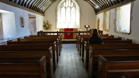
St Swithun-upon-Kingsgate Church — local attraction, which is located at St Swithun St, Winchester SO23 9JP, United Kingdom and belongs to the category — anglican church. Average visitor rating for this place — 4.6 (according to 18 ratings, information from open sources and relevant for 2022).
Exact location — St Swithun-upon-Kingsgate Church, marked on the map with a red marker.
You can get directions to St Swithun-upon-Kingsgate Church on the map from your location.
What else is interesting in Winchester? You can see all the sights if you go to the city page.
Coordinates
St Swithun-upon-Kingsgate Church, United Kingdom coordinates in decimal format: latitude — 51.059100863221104, longitude — -1.3143795747916254. When converted to degrees, minutes, seconds St Swithun-upon-Kingsgate Church has the following coordinates: 51°3′32.76 north latitude and -1°18′51.77 east longitude.
Nearby cities
The largest cities that are located nearby:
- Southampton — 18 km
- Portsmouth — 31 km
- Reading — 49 km
- Bournemouth — 55 km
- Swindon — 64 km
- Slough — 70 km
- Oxford — 77 km
- Crawley — 78 km
- Sutton — 84 km
- Watford — 91 km
- Bristol — 98 km
- Cheltenham — 107 km
- Luton — 109 km
- Eastbourne — 116 km
- Northampton — 133 km
- Gillingham — 133 km
- Basildon — 136 km
- Worcester — 140 km
- Chelmsford — 143 km
Distance to the capital
Distance to the capital (London) is about — 96 km.