
 Natal
North Jakarta
Krikilan
Kualanamu International Airport
Abdul Rachman Saleh Airport
Padang Panjang City
Lanud Wirasaba Bukateja Purbalingga
Bandara Udara Internasional ADI SOEMARMO
Ahmad Yani International Airport (SRG)
Natal
North Jakarta
Krikilan
Kualanamu International Airport
Abdul Rachman Saleh Airport
Padang Panjang City
Lanud Wirasaba Bukateja Purbalingga
Bandara Udara Internasional ADI SOEMARMO
Ahmad Yani International Airport (SRG)
Batang Tabik Waterpark on the map, Payakumbuh, Indonesia
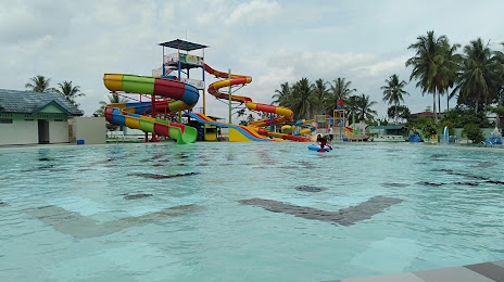
Photo
Where is located Batang Tabik Waterpark
Batang Tabik Waterpark — local attraction, which is located at QM3F+CQH, Kamuyang River, Luak, Lima Puluh Kota Regency, West Sumatra, Indonesia and belongs to the category — water park. Average visitor rating for this place — 4.2 (according to 181 rating, information from open sources and relevant for 2022).
Exact location — Batang Tabik Waterpark, marked on the map with a red marker.
You can get directions to Batang Tabik Waterpark on the map from your location.
What else is interesting in Payakumbuh? You can see all the sights if you go to the city page.
Coordinates
Batang Tabik Waterpark, Indonesia coordinates in decimal format: latitude — -0.23264270652490557, longitude — 100.64535878952809. When converted to degrees, minutes, seconds Batang Tabik Waterpark has the following coordinates: -0°13′57.51 north latitude and 100°38′43.29 east longitude.
Nearby cities
The largest cities that are located nearby:
- Padang — 85 km
- Pekanbaru — 122 km
- Dumai — 226 km
- Malacca
 (Malaysia) — 322 km
 - Muar (Malaysia) — 331 km
- Batu Pahat (Malaysia) — 343 km
- Seremban (Malaysia) — 357 km
- Jambi — 362 km
- Klang (Malaysia) — 373 km
- Shah Alam (Malaysia) — 378 km
- Subang Jaya (Malaysia) — 381 km
- Petaling Jaya (Malaysia) — 385 km
- Skudai (Malaysia) — 387 km
- Kluang (Malaysia) — 388 km
- Kuala Lumpur (Malaysia) — 390 km
- Johor Bahru (Malaysia) — 393 km
- Singapore
 (Singapore) — 393 km
 - Kuala Lumpur (Malaysia) — 394 km
- Rawang (Malaysia) — 406 km