

Vasantgad fort on the map, Karad, India
Photo
Where is located Vasantgad fort
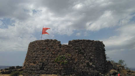
Vasantgad fort — local attraction, which is located at 8495+97G, Vasantgad, Maharashtra 415114, India and belongs to the category — fortress. Average visitor rating for this place — 4.6 (according to 49 ratings, information from open sources and relevant for 2022).
Exact location — Vasantgad fort, marked on the map with a red marker.
You can get directions to Vasantgad fort on the map from your location.
What else is interesting in Karad? You can see all the sights if you go to the city page.
Coordinates
Vasantgad fort, India coordinates in decimal format: latitude — 17.314229175725732, longitude — 74.10688164352179. When converted to degrees, minutes, seconds Vasantgad fort has the following coordinates: 17°18′51.23 north latitude and 74°6′24.77 east longitude.
Nearby cities
The largest cities that are located nearby:
- Sangli — 62 km
- Kolhapur — 65 km
- Pune — 142 km
- Belgaum — 161 km
- Solapur — 185 km
- Ahmednagar — 209 km
- Mormugao — 212 km
- Vasco da Gama — 212 km
- Navi Mumbai — 230 km
- Hubli — 233 km
- Ulhasnagar — 241 km
- Mumbai — 242 km
- Thane — 250 km
- Virar — 283 km
- Nashik — 304 km
- Aurangabad — 311 km
- Jalna — 332 km
- Bidar — 356 km
- Ballari — 374 km
Distance to the capital
Distance to the capital (New Delhi) is about — 1296 km.