 Betteshanger
Lynton
Amesbury
Marlow
Burford
Chipping Norton
Marlborough
Cairnryan
Lydney
Betteshanger
Lynton
Amesbury
Marlow
Burford
Chipping Norton
Marlborough
Cairnryan
Lydney
Barton-on-sea Beach on the map, Christchurch, United Kingdom
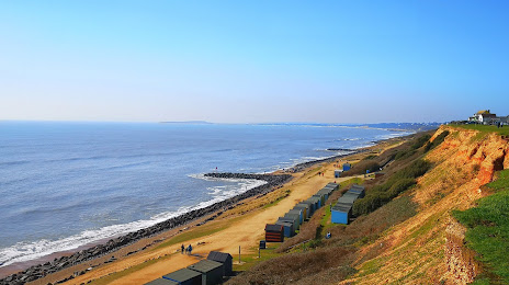
Photo
Where is located Barton-on-sea Beach
Barton-on-sea Beach — local attraction, which is located at 46 Marine Dr E, Barton on Sea, New Milton BH25 7DX, United Kingdom and belongs to the category — public beach. Average visitor rating for this place — 4.6 (according to 885 ratings, information from open sources and relevant for 2022).
Exact location — Barton-on-sea Beach, marked on the map with a red marker.
You can get directions to Barton-on-sea Beach on the map from your location.
What else is interesting in Christchurch? You can see all the sights if you go to the city page.
Coordinates
Barton-on-sea Beach, United Kingdom coordinates in decimal format: latitude — 50.73647978371179, longitude — -1.6722356435530465. When converted to degrees, minutes, seconds Barton-on-sea Beach has the following coordinates: 50°44′11.33 north latitude and -1°40′20.05 east longitude.
Nearby cities
The largest cities that are located nearby:
- Bournemouth — 7 km
- Southampton — 32 km
- Portsmouth — 49 km
- Swindon — 91 km
- Reading — 97 km
- Bristol — 97 km
- Oxford — 118 km
- Crawley — 118 km
- Slough — 118 km
- Exeter — 123 km
- Sutton — 129 km
- Cheltenham — 130 km
- Watford — 139 km
- Eastbourne — 145 km
- Luton — 157 km
- Worcester — 164 km
- Gillingham — 176 km
- Northampton — 177 km
- Basildon — 181 km
Distance to the capital
Distance to the capital (London) is about — 138 km.