 Betteshanger
Lynton
Amesbury
Marlow
Burford
Chipping Norton
Marlborough
Cairnryan
Lydney
Betteshanger
Lynton
Amesbury
Marlow
Burford
Chipping Norton
Marlborough
Cairnryan
Lydney
Oxford Island Nature Reserve on the map, Portadown, United Kingdom
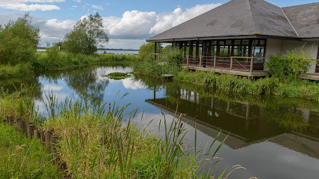
Photo
Where is located Oxford Island Nature Reserve
Oxford Island Nature Reserve — local attraction, which is located at Craigavon BT66 6NJ, United Kingdom and belongs to the category — nature preserve. Average visitor rating for this place — 4.6 (according to 506 ratings, information from open sources and relevant for 2022).
Exact location — Oxford Island Nature Reserve, marked on the map with a red marker.
You can get directions to Oxford Island Nature Reserve on the map from your location.
What else is interesting in Portadown? You can see all the sights if you go to the city page.
Coordinates
Oxford Island Nature Reserve, United Kingdom coordinates in decimal format: latitude — 54.49562142557692, longitude — -6.385107874663054. When converted to degrees, minutes, seconds Oxford Island Nature Reserve has the following coordinates: 54°29′44.24 north latitude and -6°23′6.39 east longitude.
Nearby cities
The largest cities that are located nearby:
- Belfast — 39 km
- Dublin
 (Ireland) — 119 km
 - Glasgow — 210 km
- Liverpool — 254 km
- Preston — 256 km
- Edinburgh — 264 km
- Blackburn — 270 km
- Manchester — 296 km
- Cork (Ireland) — 312 km
- Huddersfield — 318 km
- Stoke-on-Trent — 325 km
- Sunderland — 327 km
- Telford — 331 km
- Sheffield — 348 km
- Rotherham — 353 km
- Dudley — 362 km
- West Bromwich — 366 km
- Sutton Coldfield — 372 km
- Birmingham — 374 km
Distance to the capital
Distance to the capital (London) is about — 534 km.