 Betteshanger
Lynton
Amesbury
Marlow
Burford
Chipping Norton
Marlborough
Cairnryan
Lydney
Betteshanger
Lynton
Amesbury
Marlow
Burford
Chipping Norton
Marlborough
Cairnryan
Lydney
Rosyth Castle Ruins on the map, Rosyth, United Kingdom
Photo
Where is located Rosyth Castle Ruins
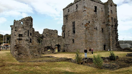
Rosyth Castle Ruins — local attraction, which is located at Dunfermline KY11 2XB, United Kingdom and belongs to the category — building. Average visitor rating for this place — 4.1 (according to 14 ratings, information from open sources and relevant for 2022).
Exact location — Rosyth Castle Ruins, marked on the map with a red marker.
You can get directions to Rosyth Castle Ruins on the map from your location.
What else is interesting in Rosyth? You can see all the sights if you go to the city page.
Coordinates
Rosyth Castle Ruins, United Kingdom coordinates in decimal format: latitude — 56.02346390140917, longitude — -3.4314166746040753. When converted to degrees, minutes, seconds Rosyth Castle Ruins has the following coordinates: 56°1′24.47 north latitude and -3°25′53.1 east longitude.
Nearby cities
The largest cities that are located nearby:
- Edinburgh — 17 km
- Glasgow — 55 km
- Sunderland — 180 km
- Belfast — 226 km
- Preston — 256 km
- Blackburn — 260 km
- Huddersfield — 285 km
- Liverpool — 292 km
- Manchester — 293 km
- Rotherham — 318 km
- Sheffield — 321 km
- Stoke-on-Trent — 345 km
- Dublin
 (Ireland) — 351 km
 - Telford — 377 km
- Sutton Coldfield — 398 km
- Dudley — 400 km
- West Bromwich — 401 km
- Birmingham — 406 km
- Leicester — 406 km
Distance to the capital
Distance to the capital (London) is about — 547 km.