 Betteshanger
Lynton
Amesbury
Marlow
Burford
Chipping Norton
Marlborough
Cairnryan
Lydney
Betteshanger
Lynton
Amesbury
Marlow
Burford
Chipping Norton
Marlborough
Cairnryan
Lydney
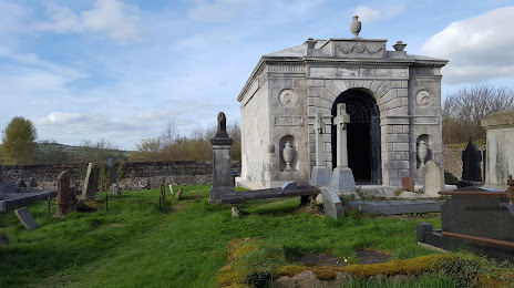
National Trust - Templetown Mausoleum on the map, Antrim, United Kingdom
Photo
Where is located National Trust - Templetown Mausoleum
National Trust - Templetown Mausoleum — local attraction, which is located at Antrim Rd, Templepatrick, Ballyclare BT39 0AH, United Kingdom and belongs to the category — $$. Average visitor rating for this place — 3.9 (according to 13 ratings, information from open sources and relevant for 2022).
Exact location — National Trust - Templetown Mausoleum, marked on the map with a red marker.
You can get directions to National Trust - Templetown Mausoleum on the map from your location.
What else is interesting in Antrim? You can see all the sights if you go to the city page.
Coordinates
National Trust - Templetown Mausoleum, United Kingdom coordinates in decimal format: latitude — 54.70632858643636, longitude — -6.095262974655014. When converted to degrees, minutes, seconds National Trust - Templetown Mausoleum has the following coordinates: 54°42′22.78 north latitude and -6°5′42.95 east longitude.
Nearby cities
The largest cities that are located nearby:
- Belfast — 22 km
- Dublin
 (Ireland) — 151 km
 - Glasgow — 175 km
- Edinburgh — 231 km
- Preston — 252 km
- Liverpool — 257 km
- Blackburn — 266 km
- Manchester — 295 km
- Sunderland — 307 km
- Huddersfield — 313 km
- Stoke-on-Trent — 328 km
- Telford — 338 km
- Sheffield — 346 km
- Cork (Ireland) — 349 km
- Rotherham — 349 km
- Dudley — 370 km
- West Bromwich — 374 km
- Sutton Coldfield — 378 km
- Birmingham — 381 km
Distance to the capital
Distance to the capital (London) is about — 534 km.