
 Ardena
Apiro
Cozzuolo
Amendolea
Grimaldi
Pignano
Case Nuove Russo
Palazzo
Lido di Rivoli
Ardena
Apiro
Cozzuolo
Amendolea
Grimaldi
Pignano
Case Nuove Russo
Palazzo
Lido di Rivoli
Castello di Cervinara on the map, Cervinara, Italy
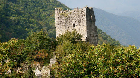
Photo
Where is located Castello di Cervinara
Castello di Cervinara — local attraction, which is located at 83012 Cervinara, Province of Avellino, Italy and belongs to the category — castle. Average visitor rating for this place — 3.6 (according to 16 ratings, information from open sources and relevant for 2022).
Exact location — Castello di Cervinara, marked on the map with a red marker.
You can get directions to Castello di Cervinara on the map from your location.
What else is interesting in Cervinara? You can see all the sights if you go to the city page.
Coordinates
Castello di Cervinara, Italy coordinates in decimal format: latitude — 41.01256710125705, longitude — 14.643137924869041. When converted to degrees, minutes, seconds Castello di Cervinara has the following coordinates: 41°0′45.24 north latitude and 14°38′35.3 east longitude.
Nearby cities
The largest cities that are located nearby:
- Naples — 35 km
- Giugliano in Campania — 36 km
- Salerno — 39 km
- Foggia — 91 km
- Latina — 151 km
- Pescara — 163 km
- Bari — 188 km
- Taranto — 229 km
- Terni — 235 km
- Perugia — 293 km
- Ancona — 300 km
- Split
 (Croatia) — 311 km
 - Messina — 323 km
- Reggio Calabria — 334 km
- Palermo — 339 km
- Mostar
 (Bosnia and Herzegovina) — 363 km
 - Rimini — 374 km
- Catania — 391 km
- Durrës
 (Albania) — 402 km
Distance to the capital
Distance to the capital (Rome) is about — 205 km.