
 Tamelalt
Centre Mikkess
Aghelad
Sebt Gzoula
Melilla
Tnine Ourika
Amezri
Centre Commune Ouled Zidane
Berkane Province
Tamelalt
Centre Mikkess
Aghelad
Sebt Gzoula
Melilla
Tnine Ourika
Amezri
Centre Commune Ouled Zidane
Berkane Province
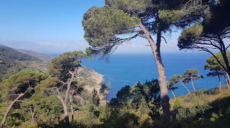
Park Rmilat on the map, Tangier, Morocco
Photo
Where is located Park Rmilat
Park Rmilat — local attraction, which is located at Tangier, Morocco and belongs to the category — park. Average visitor rating for this place — 4.5 (according to 4025 ratings, information from open sources and relevant for 2022).
Exact location — Park Rmilat, marked on the map with a red marker.
You can get directions to Park Rmilat on the map from your location.
What else is interesting in Tangier? You can see all the sights if you go to the city page.
Coordinates
Park Rmilat, Morocco coordinates in decimal format: latitude — 35.79292141872172, longitude — -5.862475975188697. When converted to degrees, minutes, seconds Park Rmilat has the following coordinates: 35°47′34.52 north latitude and -5°51′44.91 east longitude.
Nearby cities
The largest cities that are located nearby:
- Tetouan — 47 km
- Algeciras
 (Spain) — 54 km
 - Cádiz (Spain) — 94 km
- Jerez (Spain) — 106 km
- Marbella (Spain) — 118 km
- Málaga (Spain) — 157 km
- Dos Hermanas (Spain) — 169 km
- Taounate — 174 km
- Kenitra — 180 km
- Huelva (Spain) — 193 km
- Meknes — 208 km
- Sale — 209 km
- Khemisset — 216 km
- Temara — 225 km
- Taza — 238 km
- Granada (Spain) — 252 km
- Córdoba (Spain) — 253 km
- Nador — 270 km
- Mohammedia — 270 km
Distance to the capital
Distance to the capital (Rabat) is about — 222 km.