
 Winsum
Klarenbeek
Puttershoek
De Cocksdorp
Petersburg
Camperduin
Lingewaard
Oudleusen
Den Helder
Winsum
Klarenbeek
Puttershoek
De Cocksdorp
Petersburg
Camperduin
Lingewaard
Oudleusen
Den Helder
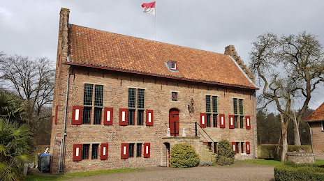
Kasteel de Kelder on the map, Doetinchem, Netherlands
Photo
Where is located Kasteel de Kelder
Kasteel de Kelder — local attraction, which is located at Kelderlaan 11, 7009 BV Doetinchem, Netherlands and belongs to the category — castle. Average visitor rating for this place — 4.3 (according to 140 ratings, information from open sources and relevant for 2022).
Exact location — Kasteel de Kelder, marked on the map with a red marker.
You can get directions to Kasteel de Kelder on the map from your location.
What else is interesting in Doetinchem? You can see all the sights if you go to the city page.
Coordinates
Kasteel de Kelder, Netherlands coordinates in decimal format: latitude — 51.9777918409917, longitude — 6.2827079253367515. When converted to degrees, minutes, seconds Kasteel de Kelder has the following coordinates: 51°58′40.05 north latitude and 6°16′57.75 east longitude.
Nearby cities
The largest cities that are located nearby:
- Arnhem — 27 km
- Apeldoorn — 35 km
- Nijmegen — 35 km
- Ede — 44 km
- Enschede — 50 km
- Moers
 (Germany) — 62 km
 - Zwolle — 63 km
- Oberhausen (Germany) — 65 km
- Amersfoort — 65 km
- Bottrop (Germany) — 66 km
- Duisburg (Germany) — 67 km
- Krefeld (Germany) — 72 km
- Mülheim (Germany) — 73 km
- Recklinghausen (Germany) — 73 km
- Gelsenkirchen (Germany) — 74 km
- 's-Hertogenbosch — 74 km
- Essen (Germany) — 75 km
- Herne (Germany) — 78 km
- Utrecht — 81 km
Distance to the capital
Distance to the capital (Amsterdam) is about — 104 km.