 Maureville
Samoëns
Gréning
Toulouse
Volx
Goudet
Méhoncourt
Saint-Hymer
Pontcarré
Maureville
Samoëns
Gréning
Toulouse
Volx
Goudet
Méhoncourt
Saint-Hymer
Pontcarré
Carrara City on the map, Maisons-Laffitte, France
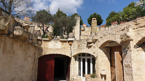
Photo
Where is located Carrara City
Carrara City — local attraction, which is located at 186 Rue Paul Doumer, 78420 Carrières-sur-Seine, France and belongs to the category — museum. Average visitor rating for this place — 4.6 (according to 29 ratings, information from open sources and relevant for 2022).
Exact location — Carrara City, marked on the map with a red marker.
You can get directions to Carrara City on the map from your location.
What else is interesting in Maisons-Laffitte? You can see all the sights if you go to the city page.
Coordinates
Carrara City, France coordinates in decimal format: latitude — 48.911280948546654, longitude — 2.1877257252256745. When converted to degrees, minutes, seconds Carrara City has the following coordinates: 48°54′40.61 north latitude and 2°11′15.81 east longitude.
Nearby cities
The largest cities that are located nearby:
- Boulogne-Billancourt — 14 km
- Rouen — 93 km
- Amiens — 105 km
- Orléans — 117 km
- Reims — 141 km
- Le Havre — 158 km
- Le Mans — 177 km
- Caen — 183 km
- Lille — 197 km
- Tours — 203 km
- Charleroi
 (Belgium) — 229 km
 - Eastbourne
 (United Kingdom) — 239 km
 - Namur (Belgium) — 255 km
- Angers — 259 km
- Brussels (Belgium) — 261 km
- Dijon — 282 km
- Crawley (United Kingdom) — 289 km
- Gillingham (United Kingdom) — 291 km
- Metz — 292 km
Distance to the capital
Distance to the capital (Paris) is about — 13 km.