
 Abou Sultan
Duma
Siris
Hinanit
Qarawat Bani Zeid
Kafr Qaddum
Biddya
Abou Sultan
Duma
Siris
Hinanit
Qarawat Bani Zeid
Kafr Qaddum
Biddya
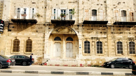
متحف جامعة الخليل on the map, Hebron, Palestinian Territory
Photo
Where is located متحف جامعة الخليل
متحف جامعة الخليل — local attraction, which is located at G3MX+36Q, Hebron and belongs to the category — museum. Average visitor rating for this place — 5.0 (according to 1 rating, information from open sources and relevant for 2022).
Exact location — متحف جامعة الخليل, marked on the map with a red marker.
You can get directions to متحف جامعة الخليل on the map from your location.
What else is interesting in Hebron? You can see all the sights if you go to the city page.
Coordinates
متحف جامعة الخليل, Palestinian Territory coordinates in decimal format: latitude — 31.53268333050734, longitude — 35.09804302470029. When converted to degrees, minutes, seconds متحف جامعة الخليل has the following coordinates: 31°31′57.66 north latitude and 35°5′52.95 east longitude.
Nearby cities
The largest cities that are located nearby:
- Jerusalem
 (Israel) — 28 km
 - Ashdod (Israel) — 51 km
- Ashqelon (Israel) — 52 km
- Bat Yam (Israel) — 63 km
- Ramat Gan (Israel) — 65 km
- Tel Aviv-Yafo (Israel) — 68 km
- Netanya (Israel) — 90 km
- Amman
 (Jordan) — 92 km
 - Irbid (Jordan) — 132 km
- Haifa (Israel) — 140 km
- Tyre
 (Lebanon) — 193 km
 - Damascus
 (Syria) — 245 km
 - Duma (Syria) — 255 km
- Beirut (Lebanon) — 263 km
- Port Said
 (Egypt) — 266 km
 - Ismailia (Egypt) — 288 km
- Suez (Egypt) — 299 km
- Tripoli (Lebanon) — 328 km
- Talkha (Egypt) — 356 km