 Betteshanger
Lynton
Amesbury
Marlow
Burford
Chipping Norton
Marlborough
Cairnryan
Lydney
Betteshanger
Lynton
Amesbury
Marlow
Burford
Chipping Norton
Marlborough
Cairnryan
Lydney
National Trust - Stoneywell on the map, Leicester, United Kingdom
Photo
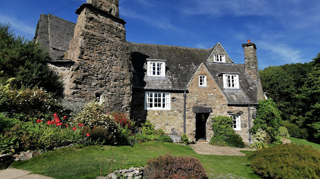
Where is located National Trust - Stoneywell
National Trust - Stoneywell — local attraction, which is located at Whitcroft's Ln, Markfield LE67 9QE, United Kingdom and belongs to the category — $$. Average visitor rating for this place — 4.8 (according to 479 ratings, information from open sources and relevant for 2022).
Exact location — National Trust - Stoneywell, marked on the map with a red marker.
You can get directions to National Trust - Stoneywell on the map from your location.
What else is interesting in Leicester? You can see all the sights if you go to the city page.
Coordinates
National Trust - Stoneywell, United Kingdom coordinates in decimal format: latitude — 52.70145542385909, longitude — -1.2646882746363344. When converted to degrees, minutes, seconds National Trust - Stoneywell has the following coordinates: 52°42′5.24 north latitude and -1°15′52.88 east longitude.
Nearby cities
The largest cities that are located nearby:
- Coventry — 36 km
- Sutton Coldfield — 47 km
- Northampton — 47 km
- Birmingham — 53 km
- West Bromwich — 59 km
- Dudley — 65 km
- Stoke-on-Trent — 80 km
- Sheffield — 85 km
- Telford — 88 km
- Worcester — 88 km
- Rotherham — 89 km
- Luton — 97 km
- Cambridge — 98 km
- Oxford — 98 km
- Cheltenham — 104 km
- Manchester — 118 km
- Huddersfield — 119 km
- Watford — 120 km
- Swindon — 127 km
Distance to the capital
Distance to the capital (London) is about — 154 km.