 Betteshanger
Lynton
Amesbury
Marlow
Burford
Chipping Norton
Marlborough
Cairnryan
Lydney
Betteshanger
Lynton
Amesbury
Marlow
Burford
Chipping Norton
Marlborough
Cairnryan
Lydney
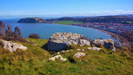
Pen-y-Dinas Hillfort on the map, Llandudno, United Kingdom
Photo
Where is located Pen-y-Dinas Hillfort
Pen-y-Dinas Hillfort — local attraction, which is located at Great Orme, Pyllau Rd, Llandudno LL30 2LU, United Kingdom and belongs to the category — historical landmark. Average visitor rating for this place — 4.9 (according to 25 ratings, information from open sources and relevant for 2022).
Exact location — Pen-y-Dinas Hillfort, marked on the map with a red marker.
You can get directions to Pen-y-Dinas Hillfort on the map from your location.
What else is interesting in Llandudno? You can see all the sights if you go to the city page.
Coordinates
Pen-y-Dinas Hillfort, United Kingdom coordinates in decimal format: latitude — 53.329845943286124, longitude — -3.8352807747073165. When converted to degrees, minutes, seconds Pen-y-Dinas Hillfort has the following coordinates: 53°19′47.45 north latitude and -3°50′7.01 east longitude.
Nearby cities
The largest cities that are located nearby:
- Liverpool — 56 km
- Preston — 88 km
- Blackburn — 99 km
- Manchester — 106 km
- Stoke-on-Trent — 115 km
- Telford — 117 km
- Huddersfield — 139 km
- Dudley — 148 km
- West Bromwich — 152 km
- Sheffield — 156 km
- Sutton Coldfield — 158 km
- Birmingham — 160 km
- Dublin
 (Ireland) — 161 km
 - Rotherham — 163 km
- Worcester — 166 km
- Coventry — 186 km
- Belfast — 195 km
- Leicester — 196 km
- Cheltenham — 198 km
Distance to the capital
Distance to the capital (London) is about — 323 km.