 Betteshanger
Lynton
Amesbury
Marlow
Burford
Chipping Norton
Marlborough
Cairnryan
Lydney
Betteshanger
Lynton
Amesbury
Marlow
Burford
Chipping Norton
Marlborough
Cairnryan
Lydney
Almondvale Park on the map, Livingston, United Kingdom
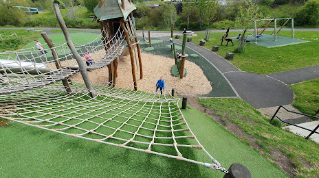
Photo
Where is located Almondvale Park
Almondvale Park — local attraction, which is located at 35 Terrace Roundabout, Livingston EH54 6WF, United Kingdom and belongs to the category — park. Average visitor rating for this place — 4.3 (according to 474 ratings, information from open sources and relevant for 2022).
Exact location — Almondvale Park, marked on the map with a red marker.
You can get directions to Almondvale Park on the map from your location.
What else is interesting in Livingston? You can see all the sights if you go to the city page.
Coordinates
Almondvale Park, United Kingdom coordinates in decimal format: latitude — 55.893718680408966, longitude — -3.5040392154213875. When converted to degrees, minutes, seconds Almondvale Park has the following coordinates: 55°53′37.39 north latitude and -3°30′14.54 east longitude.
Nearby cities
The largest cities that are located nearby:
- Edinburgh — 21 km
- Glasgow — 46 km
- Sunderland — 175 km
- Belfast — 211 km
- Preston — 242 km
- Blackburn — 247 km
- Huddersfield — 274 km
- Liverpool — 278 km
- Manchester — 280 km
- Rotherham — 308 km
- Sheffield — 310 km
- Stoke-on-Trent — 333 km
- Dublin
 (Ireland) — 335 km
 - Telford — 363 km
- Sutton Coldfield — 385 km
- Dudley — 387 km
- West Bromwich — 388 km
- Birmingham — 393 km
- Leicester — 395 km
Distance to the capital
Distance to the capital (London) is about — 536 km.