 Betteshanger
Lynton
Amesbury
Marlow
Burford
Chipping Norton
Marlborough
Cairnryan
Lydney
Betteshanger
Lynton
Amesbury
Marlow
Burford
Chipping Norton
Marlborough
Cairnryan
Lydney
Botanic Garden on the map, Durham, United Kingdom
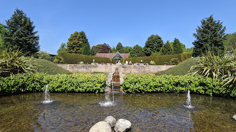
Photo
Where is located Botanic Garden
Botanic Garden — local attraction, which is located at South Rd, Durham DH1 3DF, United Kingdom and belongs to the category — botanical garden. Average visitor rating for this place — 4.6 (according to 314 ratings, information from open sources and relevant for 2022).
Exact location — Botanic Garden, marked on the map with a red marker.
You can get directions to Botanic Garden on the map from your location.
What else is interesting in Durham? You can see all the sights if you go to the city page.
Coordinates
Botanic Garden, United Kingdom coordinates in decimal format: latitude — 54.76237542929481, longitude — -1.5750367746528475. When converted to degrees, minutes, seconds Botanic Garden has the following coordinates: 54°45′44.55 north latitude and -1°34′30.13 east longitude.
Nearby cities
The largest cities that are located nearby:
- Sunderland — 19 km
- Huddersfield — 126 km
- Blackburn — 128 km
- Preston — 134 km
- Rotherham — 149 km
- Manchester — 150 km
- Sheffield — 154 km
- Edinburgh — 164 km
- Liverpool — 177 km
- Stoke-on-Trent — 200 km
- Glasgow — 205 km
- Leicester — 238 km
- Telford — 239 km
- Sutton Coldfield — 244 km
- West Bromwich — 251 km
- Dudley — 252 km
- Birmingham — 254 km
- Coventry — 262 km
- Belfast — 279 km
Distance to the capital
Distance to the capital (London) is about — 375 km.