
 Warner Robins
Wantagh
Bethel
Misty Hill Farm
United States
Wakonda Beach (R33) Airport
Wilmington
Poland
Miami International Airport
Warner Robins
Wantagh
Bethel
Misty Hill Farm
United States
Wakonda Beach (R33) Airport
Wilmington
Poland
Miami International Airport
Pier Park on the map, Sunny Isles Beach, United States
Photo
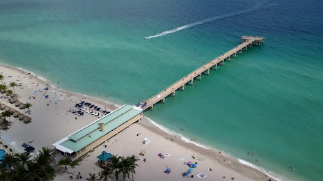
Where is located Pier Park
Pier Park — local attraction, which is located at 16501 Collins Ave, Sunny Isles Beach, FL 33160, United States and belongs to the category — park. Average visitor rating for this place — 4.6 (according to 791 rating, information from open sources and relevant for 2022).
Exact location — Pier Park, marked on the map with a red marker.
You can get directions to Pier Park on the map from your location.
What else is interesting in Sunny Isles Beach? You can see all the sights if you go to the city page.
Coordinates
Pier Park, United States coordinates in decimal format: latitude — 25.929987839802376, longitude — -80.12055637552074. When converted to degrees, minutes, seconds Pier Park has the following coordinates: 25°55′47.96 north latitude and -80°7′14 east longitude.
Nearby cities
The largest cities that are located nearby:
- Hollywood — 8 km
- Hialeah — 18 km
- Miramar — 19 km
- Pembroke Pines — 19 km
- Fort Lauderdale — 20 km
- Miami — 21 km
- Coral Springs — 39 km
- Port Saint Lucie — 149 km
- Cape Coral — 193 km
- Nassau
 (The Bahamas) — 295 km
 - Brandon — 305 km
- Orlando — 312 km
- Tampa — 318 km
- Saint Petersburg — 319 km
- Clearwater — 344 km
- Matanzas
 (Cuba) — 352 km
 - Havana (Cuba) — 377 km
- Santa Clara (Cuba) — 389 km
- Gainesville — 461 km
Distance to the capital
Distance to the capital (Washington) is about — 1472 km.