
 Vítkovce
Harhaj
Blatná Polianka
Orlov
Bzenov
Chrastné
Dolná Poruba
Kvačany
Kožuchovce
Vítkovce
Harhaj
Blatná Polianka
Orlov
Bzenov
Chrastné
Dolná Poruba
Kvačany
Kožuchovce
Sasovsky Castle on the map, Žiar nad Hronom, Slovakia
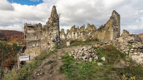
Photo
Where is located Sasovsky Castle
Sasovsky Castle — local attraction, which is located at 965 01 Žiar nad Hronom, Slovakia and belongs to the category — castle. Average visitor rating for this place — 4.6 (according to 655 ratings, information from open sources and relevant for 2022).
Exact location — Sasovsky Castle, marked on the map with a red marker.
You can get directions to Sasovsky Castle on the map from your location.
What else is interesting in Žiar nad Hronom? You can see all the sights if you go to the city page.
Coordinates
Sasovsky Castle, Slovakia coordinates in decimal format: latitude — 48.57907443806773, longitude — 18.90000802521387. When converted to degrees, minutes, seconds Sasovsky Castle has the following coordinates: 48°34′44.67 north latitude and 18°54′0.03 east longitude.
Nearby cities
The largest cities that are located nearby:
- Budapest
 (Hungary) — 121 km
 - Győr (Hungary) — 134 km
- Bielsko-Biala
 (Poland) — 137 km
 - Ostrava
 (Czech Republic) — 143 km
 - Miskolc (Hungary) — 151 km
- Székesfehérvár (Hungary) — 158 km
- Olomouc (Czech Republic) — 160 km
- Rybnik (Poland) — 169 km
- Brno (Czech Republic) — 175 km
- Košice — 176 km
- Kraków (Poland) — 181 km
- Ruda Slaska (Poland) — 184 km
- Katowice (Poland) — 186 km
- Vienna
 (Austria) — 187 km
 - Sosnowiec (Poland) — 189 km
- Gliwice (Poland) — 189 km
- Chorzow (Poland) — 189 km
- Zabrze (Poland) — 192 km
- Dabrowa Gornicza (Poland) — 193 km
Distance to the capital
Distance to the capital (Bratislava) is about — 141 km.