
 Warner Robins
Wantagh
Bethel
Misty Hill Farm
United States
Wakonda Beach (R33) Airport
Wilmington
Poland
Miami International Airport
Warner Robins
Wantagh
Bethel
Misty Hill Farm
United States
Wakonda Beach (R33) Airport
Wilmington
Poland
Miami International Airport
Four Mile Creek Greenway, Matthews on the map, Matthews, United States
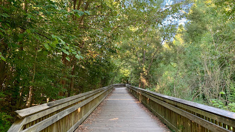
Photo
Where is located Four Mile Creek Greenway, Matthews
Four Mile Creek Greenway, Matthews — local attraction, which is located at 1102 E John St, Matthews, NC 28105, United States and belongs to the category — park. Average visitor rating for this place — 4.6 (according to 155 ratings, information from open sources and relevant for 2022).
Exact location — Four Mile Creek Greenway, Matthews, marked on the map with a red marker.
You can get directions to Four Mile Creek Greenway, Matthews on the map from your location.
What else is interesting in Matthews? You can see all the sights if you go to the city page.
Coordinates
Four Mile Creek Greenway, Matthews, United States coordinates in decimal format: latitude — 35.105884683120415, longitude — -80.71216937520744. When converted to degrees, minutes, seconds Four Mile Creek Greenway, Matthews has the following coordinates: 35°6′21.18 north latitude and -80°42′43.81 east longitude.
Nearby cities
The largest cities that are located nearby:
- Charlotte — 16 km
- Winston-Salem — 117 km
- Columbia — 127 km
- Greensboro — 135 km
- Fayetteville — 167 km
- Cary — 190 km
- Durham — 190 km
- Raleigh — 201 km
- Charleston — 269 km
- Knoxville — 301 km
- Savannah — 337 km
- Atlanta — 369 km
- Richmond — 394 km
- Chattanooga — 415 km
- Chesapeake — 433 km
- Norfolk — 437 km
- Hampton — 441 km
- Virginia Beach — 462 km
- Alexandria — 516 km
Distance to the capital
Distance to the capital (Washington) is about — 534 km.