
 Warner Robins
Wantagh
Bethel
Misty Hill Farm
United States
Wakonda Beach (R33) Airport
Wilmington
Poland
Miami International Airport
Warner Robins
Wantagh
Bethel
Misty Hill Farm
United States
Wakonda Beach (R33) Airport
Wilmington
Poland
Miami International Airport
Tiger Mountain State Forest on the map, Issaquah, United States
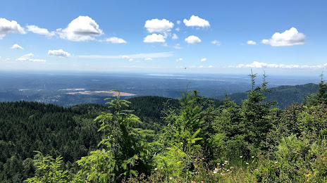
Photo
Where is located Tiger Mountain State Forest
Tiger Mountain State Forest — local attraction, which is located at Issaquah, WA 98027, United States and belongs to the category — state park. Average visitor rating for this place — 4.7 (according to 1622 ratings, information from open sources and relevant for 2022).
Exact location — Tiger Mountain State Forest, marked on the map with a red marker.
You can get directions to Tiger Mountain State Forest on the map from your location.
What else is interesting in Issaquah? You can see all the sights if you go to the city page.
Coordinates
Tiger Mountain State Forest, United States coordinates in decimal format: latitude — 47.488128154478375, longitude — -121.96143327482422. When converted to degrees, minutes, seconds Tiger Mountain State Forest has the following coordinates: 47°29′17.26 north latitude and -121°57′41.16 east longitude.
Nearby cities
The largest cities that are located nearby:
- Bellevue — 15 km
- Seattle — 24 km
- Tacoma — 43 km
- Victoria
 (Canada) — 139 km
 - Abbotsford (Canada) — 170 km
- Delta (Canada) — 187 km
- Surrey (Canada) — 192 km
- Richmond (Canada) — 198 km
- Coquitlam (Canada) — 201 km
- Burnaby (Canada) — 203 km
- Anmore (Canada) — 206 km
- Vancouver (Canada) — 209 km
- Portland — 227 km
- Salem — 297 km
- Kelowna (Canada) — 317 km
- Spokane — 343 km
- Eugene — 394 km
- Boise — 636 km
- Calgary (Canada) — 676 km
Distance to the capital
Distance to the capital (Washington) is about — 3710 km.