
 Warner Robins
Wantagh
Bethel
Misty Hill Farm
United States
Wakonda Beach (R33) Airport
Wilmington
Poland
Miami International Airport
Warner Robins
Wantagh
Bethel
Misty Hill Farm
United States
Wakonda Beach (R33) Airport
Wilmington
Poland
Miami International Airport
Governor's Mansion on the map, Frankfort, United States
Photo
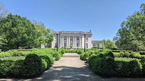
Where is located Governor's Mansion
Governor's Mansion — local attraction, which is located at 704 Capital Ave, Frankfort, KY 40601, United States and belongs to the category — building. Average visitor rating for this place — 4.4 (according to 75 ratings, information from open sources and relevant for 2022).
Exact location — Governor's Mansion, marked on the map with a red marker.
You can get directions to Governor's Mansion on the map from your location.
What else is interesting in Frankfort? You can see all the sights if you go to the city page.
Coordinates
Governor's Mansion, United States coordinates in decimal format: latitude — 38.19322877975807, longitude — -84.8734992544696. When converted to degrees, minutes, seconds Governor's Mansion has the following coordinates: 38°11′35.62 north latitude and -84°52′24.6 east longitude.
Nearby cities
The largest cities that are located nearby:
- Louisville — 77 km
- Cincinnati — 104 km
- Indianapolis — 205 km
- Springfield — 211 km
- Evansville — 237 km
- Columbus — 251 km
- Knoxville — 262 km
- Nashville — 282 km
- Clarksville — 288 km
- Fort Wayne — 319 km
- Chattanooga — 351 km
- Toledo — 398 km
- South Bend — 401 km
- Huntsville — 414 km
- Akron — 424 km
- Cleveland — 450 km
- Aurora — 452 km
- Joliet — 453 km
- Ann Arbor — 460 km
Distance to the capital
Distance to the capital (Washington) is about — 686 km.