
 Warner Robins
Wantagh
Bethel
Misty Hill Farm
United States
Wakonda Beach (R33) Airport
Wilmington
Poland
Miami International Airport
Warner Robins
Wantagh
Bethel
Misty Hill Farm
United States
Wakonda Beach (R33) Airport
Wilmington
Poland
Miami International Airport
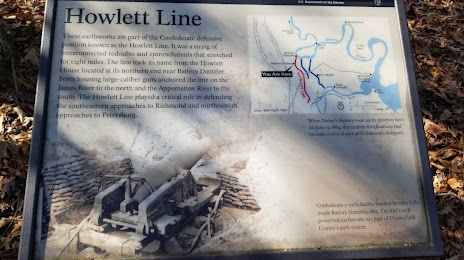
Parker's Battery on the map, Colonial Heights, United States
Photo
Where is located Parker's Battery
Parker's Battery — local attraction, which is located at 1801-1841 Ware Bottom Spring Rd, Chester, VA 23836, United States and belongs to the category — historical landmark. Average visitor rating for this place — 4.4 (according to 34 ratings, information from open sources and relevant for 2022).
Exact location — Parker's Battery, marked on the map with a red marker.
You can get directions to Parker's Battery on the map from your location.
What else is interesting in Colonial Heights? You can see all the sights if you go to the city page.
Coordinates
Parker's Battery, United States coordinates in decimal format: latitude — 37.31281378113013, longitude — -77.40138587514625. When converted to degrees, minutes, seconds Parker's Battery has the following coordinates: 37°18′46.13 north latitude and -77°24′4.99 east longitude.
Nearby cities
The largest cities that are located nearby:
- Richmond — 33 km
- Hampton — 97 km
- Norfolk — 109 km
- Chesapeake — 113 km
- Virginia Beach — 134 km
- Alexandria — 175 km
- Durham — 192 km
- Raleigh — 196 km
- Cary — 202 km
- Baltimore — 236 km
- Greensboro — 249 km
- Fayetteville — 276 km
- Winston-Salem — 283 km
- Philadelphia — 355 km
- Charlotte — 382 km
- Toms River — 405 km
- Allentown — 405 km
- Pittsburgh — 415 km
- Edison — 441 km
Distance to the capital
Distance to the capital (Washington) is about — 180 km.