
 Warner Robins
Wantagh
Bethel
Misty Hill Farm
United States
Wakonda Beach (R33) Airport
Wilmington
Poland
Miami International Airport
Warner Robins
Wantagh
Bethel
Misty Hill Farm
United States
Wakonda Beach (R33) Airport
Wilmington
Poland
Miami International Airport
Quebec 01 Missile Alert Facility State Historic Site on the map, Cheyenne, United States
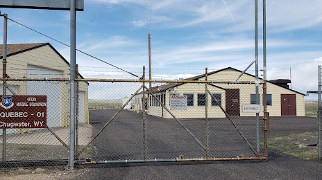
Photo
Where is located Quebec 01 Missile Alert Facility State Historic Site
Quebec 01 Missile Alert Facility State Historic Site — local attraction, which is located at 2025 Co Rd 238, Cheyenne, WY 82009, United States and belongs to the category — museum. Average visitor rating for this place — 4.9 (according to 91 rating, information from open sources and relevant for 2022).
Exact location — Quebec 01 Missile Alert Facility State Historic Site, marked on the map with a red marker.
You can get directions to Quebec 01 Missile Alert Facility State Historic Site on the map from your location.
What else is interesting in Cheyenne? You can see all the sights if you go to the city page.
Coordinates
Quebec 01 Missile Alert Facility State Historic Site, United States coordinates in decimal format: latitude — 41.543072943916926, longitude — -104.90273827501994. When converted to degrees, minutes, seconds Quebec 01 Missile Alert Facility State Historic Site has the following coordinates: 41°32′35.06 north latitude and -104°54′9.86 east longitude.
Nearby cities
The largest cities that are located nearby:
- Fort Collins — 65 km
- Thornton — 141 km
- Westminster — 145 km
- Arvada — 150 km
- Denver — 156 km
- Aurora — 156 km
- Lakewood — 160 km
- Colorado Springs — 255 km
- Pueblo — 320 km
- Provo — 586 km
- Salt Lake City — 594 km
- West Jordan — 600 km
- West Valley City — 604 km
- Lincoln — 681 km
- Albuquerque — 689 km
- Sioux Falls — 701 km
- Amarillo — 708 km
- Valencia — 721 km
- Omaha — 733 km
Distance to the capital
Distance to the capital (Washington) is about — 2374 km.