
 Warner Robins
Wantagh
Bethel
Misty Hill Farm
United States
Wakonda Beach (R33) Airport
Wilmington
Poland
Miami International Airport
Warner Robins
Wantagh
Bethel
Misty Hill Farm
United States
Wakonda Beach (R33) Airport
Wilmington
Poland
Miami International Airport
Skyline Park on the map, Mesa, United States
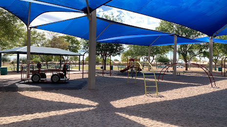
Photo
Where is located Skyline Park
Skyline Park — local attraction, which is located at 655 S Crismon Rd, Mesa, AZ 85208, United States and belongs to the category — park. Average visitor rating for this place — 4.5 (according to 1140 ratings, information from open sources and relevant for 2022).
Exact location — Skyline Park, marked on the map with a red marker.
You can get directions to Skyline Park on the map from your location.
What else is interesting in Mesa? You can see all the sights if you go to the city page.
Coordinates
Skyline Park, United States coordinates in decimal format: latitude — 33.40229907560801, longitude — -111.61245537525247. When converted to degrees, minutes, seconds Skyline Park has the following coordinates: 33°24′8.28 north latitude and -111°36′44.84 east longitude.
Nearby cities
The largest cities that are located nearby:
- Gilbert — 8 km
- Tempe — 10 km
- Chandler — 12 km
- Scottsdale — 12 km
- Phoenix — 23 km
- Glendale — 35 km
- Peoria — 42 km
- Tucson — 157 km
- Nogales — 245 km
- San Luis Río Colorado
 (Mexico) — 294 km
 - Mexicali (Mexico) — 348 km
- Henderson — 404 km
- Las Vegas — 424 km
- North Las Vegas — 425 km
- Spring Valley — 426 km
- Ensenada (Mexico) — 480 km
- Hermosillo (Mexico) — 487 km
- Escondido — 488 km
- Valencia — 490 km
Distance to the capital
Distance to the capital (Washington) is about — 3145 km.