
 Warner Robins
Wantagh
Bethel
Misty Hill Farm
United States
Wakonda Beach (R33) Airport
Wilmington
Poland
Miami International Airport
Warner Robins
Wantagh
Bethel
Misty Hill Farm
United States
Wakonda Beach (R33) Airport
Wilmington
Poland
Miami International Airport
Simonian Farms on the map, Fresno, United States
Photo
Where is located Simonian Farms
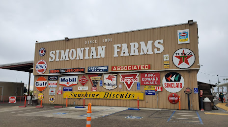
Simonian Farms — local attraction, which is located at 2629 S Clovis Ave, Fresno, CA 93725, United States and belongs to the category — farm. Average visitor rating for this place — 4.7 (according to 122 ratings, information from open sources and relevant for 2022).
Exact location — Simonian Farms, marked on the map with a red marker.
You can get directions to Simonian Farms on the map from your location.
What else is interesting in Fresno? You can see all the sights if you go to the city page.
Coordinates
Simonian Farms, United States coordinates in decimal format: latitude — 36.706756273843574, longitude — -119.69962837516326. When converted to degrees, minutes, seconds Simonian Farms has the following coordinates: 36°42′24.32 north latitude and -119°41′58.66 east longitude.
Nearby cities
The largest cities that are located nearby:
- Visalia — 63 km
- Modesto — 146 km
- Bakersfield — 166 km
- Salinas — 167 km
- Stockton — 188 km
- San Jose — 197 km
- Santa Clara — 203 km
- Sunnyvale — 210 km
- Fremont — 213 km
- Hayward — 226 km
- Concord — 239 km
- Oakland — 248 km
- Berkeley — 251 km
- Sacramento — 252 km
- Roseville — 257 km
- Fairfield — 258 km
- San Francisco — 258 km
- Richmond — 260 km
- Vallejo — 263 km
Distance to the capital
Distance to the capital (Washington) is about — 3723 km.