
 Warner Robins
Wantagh
Bethel
Misty Hill Farm
United States
Wakonda Beach (R33) Airport
Wilmington
Poland
Miami International Airport
Warner Robins
Wantagh
Bethel
Misty Hill Farm
United States
Wakonda Beach (R33) Airport
Wilmington
Poland
Miami International Airport
Commemorative Air Force Minnesota Wing on the map, Woodbury, United States
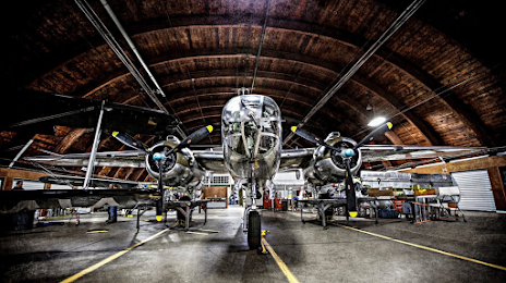
Photo
Where is located Commemorative Air Force Minnesota Wing
Commemorative Air Force Minnesota Wing — local attraction, which is located at 310 Airport Rd, South St Paul, MN 55075, United States and belongs to the category — museum. Average visitor rating for this place — 4.8 (according to 99 ratings, information from open sources and relevant for 2022).
Exact location — Commemorative Air Force Minnesota Wing, marked on the map with a red marker.
You can get directions to Commemorative Air Force Minnesota Wing on the map from your location.
What else is interesting in Woodbury? You can see all the sights if you go to the city page.
Coordinates
Commemorative Air Force Minnesota Wing, United States coordinates in decimal format: latitude — 44.861448857708055, longitude — -93.02888017491321. When converted to degrees, minutes, seconds Commemorative Air Force Minnesota Wing has the following coordinates: 44°51′41.22 north latitude and -93°1′43.97 east longitude.
Nearby cities
The largest cities that are located nearby:
- Saint Paul — 11 km
- Minneapolis — 25 km
- Sioux Falls — 339 km
- Madison — 353 km
- Des Moines — 371 km
- Green Bay — 392 km
- Rockford — 431 km
- Milwaukee — 458 km
- Omaha — 478 km
- Aurora — 518 km
- Naperville — 529 km
- Peoria — 546 km
- Lincoln — 550 km
- Joliet — 552 km
- Chicago — 553 km
- Winnipeg
 (Canada) — 625 km
 - Grand Rapids — 629 km
- North Kansas City — 654 km
- Independence — 657 km
Distance to the capital
Distance to the capital (Washington) is about — 1477 km.