
 Warner Robins
Wantagh
Bethel
Misty Hill Farm
United States
Wakonda Beach (R33) Airport
Wilmington
Poland
Miami International Airport
Warner Robins
Wantagh
Bethel
Misty Hill Farm
United States
Wakonda Beach (R33) Airport
Wilmington
Poland
Miami International Airport
Bell Slough State Wildlife Management Area on the map, Conway, United States
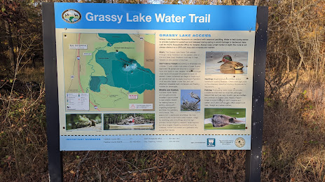
Photo
Where is located Bell Slough State Wildlife Management Area
Bell Slough State Wildlife Management Area — local attraction, which is located at Mayflower, AR 72106, United States and belongs to the category — wildlife refuge. Average visitor rating for this place — 4.4 (according to 112 ratings, information from open sources and relevant for 2022).
Exact location — Bell Slough State Wildlife Management Area, marked on the map with a red marker.
You can get directions to Bell Slough State Wildlife Management Area on the map from your location.
What else is interesting in Conway? You can see all the sights if you go to the city page.
Coordinates
Bell Slough State Wildlife Management Area, United States coordinates in decimal format: latitude — 34.95384470961976, longitude — -92.41736837521152. When converted to degrees, minutes, seconds Bell Slough State Wildlife Management Area has the following coordinates: 34°57′13.84 north latitude and -92°25′2.53 east longitude.
Nearby cities
The largest cities that are located nearby:
- Little Rock — 40 km
- Memphis — 216 km
- Springfield — 246 km
- Shreveport — 309 km
- Tulsa — 338 km
- Jackson — 374 km
- Saint Louis — 437 km
- Norman — 452 km
- Plano — 456 km
- Garland — 458 km
- Frisco — 459 km
- Oklahoma City — 459 km
- Richardson — 463 km
- Mesquite — 464 km
- Olathe — 467 km
- Overland Park — 471 km
- Independence — 474 km
- Carrollton — 474 km
- Dallas — 479 km
Distance to the capital
Distance to the capital (Washington) is about — 1434 km.