
 Warner Robins
Wantagh
Bethel
Misty Hill Farm
United States
Wakonda Beach (R33) Airport
Wilmington
Poland
Miami International Airport
Warner Robins
Wantagh
Bethel
Misty Hill Farm
United States
Wakonda Beach (R33) Airport
Wilmington
Poland
Miami International Airport
Marina Beach Park on the map, Edmonds, United States
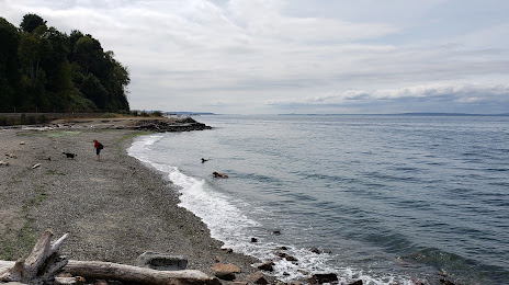
Photo
Where is located Marina Beach Park
Marina Beach Park — local attraction, which is located at 470 Admiral Way, Edmonds, WA 98020, United States and belongs to the category — park. Average visitor rating for this place — 4.7 (according to 2071 rating, information from open sources and relevant for 2022).
Exact location — Marina Beach Park, marked on the map with a red marker.
You can get directions to Marina Beach Park on the map from your location.
What else is interesting in Edmonds? You can see all the sights if you go to the city page.
Coordinates
Marina Beach Park, United States coordinates in decimal format: latitude — 47.80505735185586, longitude — -122.3940413748131. When converted to degrees, minutes, seconds Marina Beach Park has the following coordinates: 47°48′18.21 north latitude and -122°23′38.55 east longitude.
Nearby cities
The largest cities that are located nearby:
- Seattle — 23 km
- Bellevue — 26 km
- Tacoma — 62 km
- Victoria
 (Canada) — 100 km
 - Abbotsford (Canada) — 138 km
- Delta (Canada) — 150 km
- Surrey (Canada) — 156 km
- Richmond (Canada) — 160 km
- Coquitlam (Canada) — 166 km
- Burnaby (Canada) — 166 km
- Anmore (Canada) — 170 km
- Vancouver (Canada) — 171 km
- Portland — 254 km
- Kelowna (Canada) — 308 km
- Salem — 321 km
- Spokane — 369 km
- Eugene — 419 km
- Boise — 677 km
- Calgary (Canada) — 679 km
Distance to the capital
Distance to the capital (Washington) is about — 3741 km.