
 Warner Robins
Wantagh
Bethel
Misty Hill Farm
United States
Wakonda Beach (R33) Airport
Wilmington
Poland
Miami International Airport
Warner Robins
Wantagh
Bethel
Misty Hill Farm
United States
Wakonda Beach (R33) Airport
Wilmington
Poland
Miami International Airport
Fischer Park on the map, New Braunfels, United States
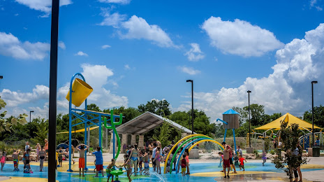
Photo
Where is located Fischer Park
Fischer Park — local attraction, which is located at 1935 Hilltop Summit Road, New Braunfels, TX 78130, United States and belongs to the category — park. Average visitor rating for this place — 4.7 (according to 1147 ratings, information from open sources and relevant for 2022).
Exact location — Fischer Park, marked on the map with a red marker.
You can get directions to Fischer Park on the map from your location.
What else is interesting in New Braunfels? You can see all the sights if you go to the city page.
Coordinates
Fischer Park, United States coordinates in decimal format: latitude — 29.677450635292953, longitude — -98.11100477534406. When converted to degrees, minutes, seconds Fischer Park has the following coordinates: 29°40′38.82 north latitude and -98°6′39.62 east longitude.
Nearby cities
The largest cities that are located nearby:
- San Antonio — 47 km
- Austin — 72 km
- Killeen — 161 km
- Corpus Christi — 222 km
- Waco — 224 km
- Piedras Negras
 (Mexico) — 258 km
 - Houston — 264 km
- Laredo — 275 km
- Ciudad Acuna (Mexico) — 276 km
- Nuevo Laredo (Mexico) — 283 km
- Abilene — 339 km
- Fort Worth — 345 km
- Arlington — 348 km
- Grand Prairie — 352 km
- Irving — 361 km
- Dallas — 362 km
- Mesquite — 367 km
- Carrollton — 380 km
- Garland — 381 km
Distance to the capital
Distance to the capital (Washington) is about — 2184 km.