
 Warner Robins
Wantagh
Bethel
Misty Hill Farm
United States
Wakonda Beach (R33) Airport
Wilmington
Poland
Miami International Airport
Warner Robins
Wantagh
Bethel
Misty Hill Farm
United States
Wakonda Beach (R33) Airport
Wilmington
Poland
Miami International Airport
ClimbZone Laurel on the map, Beltsville, United States
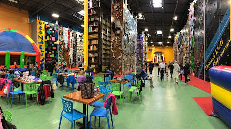
Photo
Where is located ClimbZone Laurel
ClimbZone Laurel — local attraction, which is located at 13200 Mid Atlantic Blvd Ste 130, Laurel, MD 20708, United States and belongs to the category — adventure sports center. Average visitor rating for this place — 4.6 (according to 1101 rating, information from open sources and relevant for 2022).
Exact location — ClimbZone Laurel, marked on the map with a red marker.
You can get directions to ClimbZone Laurel on the map from your location.
What else is interesting in Beltsville? You can see all the sights if you go to the city page.
Coordinates
ClimbZone Laurel, United States coordinates in decimal format: latitude — 39.072025397356576, longitude — -76.86837697509506. When converted to degrees, minutes, seconds ClimbZone Laurel has the following coordinates: 39°4′19.29 north latitude and -76°52′6.16 east longitude.
Nearby cities
The largest cities that are located nearby:
- Alexandria — 28 km
- Baltimore — 38 km
- Richmond — 172 km
- Philadelphia — 179 km
- Allentown — 211 km
- Hampton — 227 km
- Norfolk — 248 km
- Toms River — 251 km
- Virginia Beach — 255 km
- Chesapeake — 257 km
- Edison — 266 km
- Elizabeth — 289 km
- Newark — 296 km
- Pittsburgh — 303 km
- Brooklyn — 306 km
- New York — 306 km
- Paterson — 309 km
- Yonkers — 327 km
- Stamford — 359 km
Distance to the capital
Distance to the capital (Washington) is about — 23 km.