
 Warner Robins
Wantagh
Bethel
Misty Hill Farm
United States
Wakonda Beach (R33) Airport
Wilmington
Poland
Miami International Airport
Warner Robins
Wantagh
Bethel
Misty Hill Farm
United States
Wakonda Beach (R33) Airport
Wilmington
Poland
Miami International Airport
Montgomery Museum of Art & History on the map, Christiansburg, United States
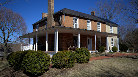
Photo
Where is located Montgomery Museum of Art & History
Montgomery Museum of Art & History — local attraction, which is located at 300 Pepper St SE, Christiansburg, VA 24073, United States and belongs to the category — museum. Average visitor rating for this place — 4.5 (according to 49 ratings, information from open sources and relevant for 2022).
Exact location — Montgomery Museum of Art & History, marked on the map with a red marker.
You can get directions to Montgomery Museum of Art & History on the map from your location.
What else is interesting in Christiansburg? You can see all the sights if you go to the city page.
Coordinates
Montgomery Museum of Art & History, United States coordinates in decimal format: latitude — 37.12864698729602, longitude — -80.40380707515138. When converted to degrees, minutes, seconds Montgomery Museum of Art & History has the following coordinates: 37°7′43.13 north latitude and -80°24′13.71 east longitude.
Nearby cities
The largest cities that are located nearby:
- Winston-Salem — 115 km
- Greensboro — 129 km
- Durham — 184 km
- Cary — 208 km
- Charlotte — 214 km
- Raleigh — 218 km
- Richmond — 265 km
- Fayetteville — 268 km
- Knoxville — 340 km
- Alexandria — 344 km
- Columbia — 351 km
- Hampton — 359 km
- Norfolk — 366 km
- Chesapeake — 367 km
- Pittsburgh — 368 km
- Columbus — 382 km
- Virginia Beach — 393 km
- Baltimore — 403 km
- Cincinnati — 414 km
Distance to the capital
Distance to the capital (Washington) is about — 355 km.