
 Warner Robins
Wantagh
Bethel
Misty Hill Farm
United States
Wakonda Beach (R33) Airport
Wilmington
Poland
Miami International Airport
Warner Robins
Wantagh
Bethel
Misty Hill Farm
United States
Wakonda Beach (R33) Airport
Wilmington
Poland
Miami International Airport
Cloer Family Vineyards on the map, Apex, United States
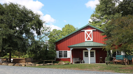
Photo
Where is located Cloer Family Vineyards
Cloer Family Vineyards — local attraction, which is located at 8624 Castleberry Rd, Apex, NC 27523, United States and belongs to the category — winery. Average visitor rating for this place — 4.9 (according to 79 ratings, information from open sources and relevant for 2022).
Exact location — Cloer Family Vineyards, marked on the map with a red marker.
You can get directions to Cloer Family Vineyards on the map from your location.
What else is interesting in Apex? You can see all the sights if you go to the city page.
Coordinates
Cloer Family Vineyards, United States coordinates in decimal format: latitude — 35.76699280595345, longitude — -78.92936837518943. When converted to degrees, minutes, seconds Cloer Family Vineyards has the following coordinates: 35°46′1.17 north latitude and -78°55′45.73 east longitude.
Nearby cities
The largest cities that are located nearby:
- Cary — 9 km
- Raleigh — 20 km
- Durham — 29 km
- Fayetteville — 75 km
- Greensboro — 92 km
- Winston-Salem — 131 km
- Charlotte — 188 km
- Richmond — 235 km
- Chesapeake — 254 km
- Norfolk — 258 km
- Hampton — 264 km
- Columbia — 277 km
- Virginia Beach — 283 km
- Charleston — 342 km
- Alexandria — 374 km
- Baltimore — 437 km
- Knoxville — 454 km
- Savannah — 455 km
- Pittsburgh — 529 km
Distance to the capital
Distance to the capital (Washington) is about — 387 km.