
 Warner Robins
Wantagh
Bethel
Misty Hill Farm
United States
Wakonda Beach (R33) Airport
Wilmington
Poland
Miami International Airport
Warner Robins
Wantagh
Bethel
Misty Hill Farm
United States
Wakonda Beach (R33) Airport
Wilmington
Poland
Miami International Airport
The Country Club of South Carolina on the map, Florence, United States
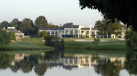
Photo
Where is located The Country Club of South Carolina
The Country Club of South Carolina — local attraction, which is located at 3525 McDonald Blvd, Florence, SC 29506, United States and belongs to the category — golf course. Average visitor rating for this place — 4.5 (according to 84 ratings, information from open sources and relevant for 2022).
Exact location — The Country Club of South Carolina, marked on the map with a red marker.
You can get directions to The Country Club of South Carolina on the map from your location.
What else is interesting in Florence? You can see all the sights if you go to the city page.
Coordinates
The Country Club of South Carolina, United States coordinates in decimal format: latitude — 34.21340525708491, longitude — -79.73961786513807. When converted to degrees, minutes, seconds The Country Club of South Carolina has the following coordinates: 34°12′48.26 north latitude and -79°44′22.62 east longitude.
Nearby cities
The largest cities that are located nearby:
- Columbia — 119 km
- Fayetteville — 124 km
- Charlotte — 150 km
- Charleston — 158 km
- Cary — 197 km
- Raleigh — 202 km
- Greensboro — 208 km
- Durham — 213 km
- Winston-Salem — 215 km
- Savannah — 265 km
- Chesapeake — 419 km
- Knoxville — 420 km
- Richmond — 422 km
- Norfolk — 425 km
- Atlanta — 428 km
- Hampton — 435 km
- Virginia Beach — 445 km
- Jacksonville — 464 km
- Chattanooga — 511 km
Distance to the capital
Distance to the capital (Washington) is about — 575 km.