
 Warner Robins
Wantagh
Bethel
Misty Hill Farm
United States
Wakonda Beach (R33) Airport
Wilmington
Poland
Miami International Airport
Warner Robins
Wantagh
Bethel
Misty Hill Farm
United States
Wakonda Beach (R33) Airport
Wilmington
Poland
Miami International Airport
Fort Ringgold on the map, Rio Grande City, United States
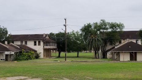
Photo
Where is located Fort Ringgold
Fort Ringgold — local attraction, which is located at Ringgold Ave, Rio Grande City, TX 78582, United States and belongs to the category — historical place. Average visitor rating for this place — 4.5 (according to 32 ratings, information from open sources and relevant for 2022).
Exact location — Fort Ringgold, marked on the map with a red marker.
You can get directions to Fort Ringgold on the map from your location.
What else is interesting in Rio Grande City? You can see all the sights if you go to the city page.
Coordinates
Fort Ringgold, United States coordinates in decimal format: latitude — 26.37561022571125, longitude — -98.80701485565531. When converted to degrees, minutes, seconds Fort Ringgold has the following coordinates: 26°22′32.2 north latitude and -98°48′25.25 east longitude.
Nearby cities
The largest cities that are located nearby:
- McAllen — 62 km
- Reynosa
 (Mexico) — 63 km
 - Nuevo Laredo (Mexico) — 141 km
- Brownsville — 142 km
- Matamoros (Mexico) — 143 km
- Laredo — 143 km
- Apodaca (Mexico) — 151 km
- San Nicolas de los Garza (Mexico) — 162 km
- General Escobedo (Mexico) — 163 km
- Guadalupe (Mexico) — 163 km
- Monterrey (Mexico) — 168 km
- San Pedro Garza García (Mexico) — 177 km
- Santa Catarina (Mexico) — 181 km
- Corpus Christi — 210 km
- Saltillo (Mexico) — 241 km
- Monclova (Mexico) — 263 km
- Ciudad Victoria (Mexico) — 294 km
- Piedras Negras (Mexico) — 305 km
- San Antonio — 338 km
Distance to the capital
Distance to the capital (Washington) is about — 2459 km.