
 Warner Robins
Wantagh
Bethel
Misty Hill Farm
United States
Wakonda Beach (R33) Airport
Wilmington
Poland
Miami International Airport
Warner Robins
Wantagh
Bethel
Misty Hill Farm
United States
Wakonda Beach (R33) Airport
Wilmington
Poland
Miami International Airport
Chamisal Vineyards on the map, Arroyo Grande, United States
Photo
Where is located Chamisal Vineyards
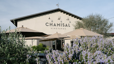
Chamisal Vineyards — local attraction, which is located at 7525 Orcutt Rd, San Luis Obispo, CA 93401, United States and belongs to the category — winery. Average visitor rating for this place — 4.6 (according to 78 ratings, information from open sources and relevant for 2022).
Exact location — Chamisal Vineyards, marked on the map with a red marker.
You can get directions to Chamisal Vineyards on the map from your location.
What else is interesting in Arroyo Grande? You can see all the sights if you go to the city page.
Coordinates
Chamisal Vineyards, United States coordinates in decimal format: latitude — 35.13908349234324, longitude — -120.52288773452185. When converted to degrees, minutes, seconds Chamisal Vineyards has the following coordinates: 35°8′20.7 north latitude and -120°31′22.4 east longitude.
Nearby cities
The largest cities that are located nearby:
- Bakersfield — 145 km
- Oxnard — 165 km
- Visalia — 177 km
- Simi Valley — 190 km
- Thousand Oaks — 192 km
- Fresno — 194 km
- Salinas — 197 km
- Santa Clarita — 198 km
- Santa Clarita — 203 km
- Lancaster — 227 km
- Universal City — 232 km
- Palmdale — 233 km
- Burbank — 233 km
- Glendale — 239 km
- Inglewood — 242 km
- Los Angeles — 245 km
- Pasadena — 248 km
- Torrance — 251 km
- East Los Angeles — 253 km
Distance to the capital
Distance to the capital (Washington) is about — 3848 km.