 Betteshanger
Lynton
Amesbury
Marlow
Burford
Chipping Norton
Marlborough
Cairnryan
Lydney
Betteshanger
Lynton
Amesbury
Marlow
Burford
Chipping Norton
Marlborough
Cairnryan
Lydney
A La Ronde on the map, Exmouth, United Kingdom
Photo
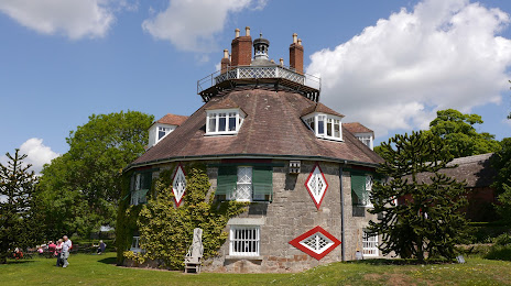
Where is located A La Ronde
A La Ronde — local attraction, which is located at Summer Ln, Exmouth EX8 5BD, United Kingdom and belongs to the category — $$. Average visitor rating for this place — 4.6 (according to 996 ratings, information from open sources and relevant for 2022).
Exact location — A La Ronde, marked on the map with a red marker.
You can get directions to A La Ronde on the map from your location.
What else is interesting in Exmouth? You can see all the sights if you go to the city page.
Coordinates
A La Ronde, United Kingdom coordinates in decimal format: latitude — 50.64165636200649, longitude — -3.40890637471225. When converted to degrees, minutes, seconds A La Ronde has the following coordinates: 50°38′29.96 north latitude and -3°24′32.06 east longitude.
Nearby cities
The largest cities that are located nearby:
- Exeter — 14 km
- Bournemouth — 108 km
- Bristol — 108 km
- Southampton — 144 km
- Swindon — 153 km
- Portsmouth — 164 km
- Cheltenham — 168 km
- Reading — 191 km
- Worcester — 192 km
- Oxford — 194 km
- Slough — 218 km
- Dudley — 228 km
- Crawley — 230 km
- Birmingham — 230 km
- West Bromwich — 230 km
- Coventry — 235 km
- Telford — 237 km
- Sutton — 237 km
- Watford — 237 km
Distance to the capital
Distance to the capital (London) is about — 249 km.