 Betteshanger
Lynton
Amesbury
Marlow
Burford
Chipping Norton
Marlborough
Cairnryan
Lydney
Betteshanger
Lynton
Amesbury
Marlow
Burford
Chipping Norton
Marlborough
Cairnryan
Lydney
Harlow Museum & Walled Gardens on the map, Harlow, United Kingdom
Photo
Where is located Harlow Museum & Walled Gardens
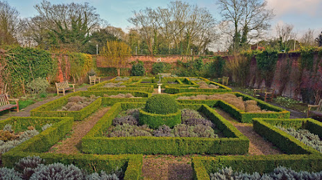
Harlow Museum & Walled Gardens — local attraction, which is located at Muskham Rd, Harlow CM20 2LF, United Kingdom and belongs to the category — museum. Average visitor rating for this place — 4.4 (according to 128 ratings, information from open sources and relevant for 2022).
Exact location — Harlow Museum & Walled Gardens, marked on the map with a red marker.
You can get directions to Harlow Museum & Walled Gardens on the map from your location.
What else is interesting in Harlow? You can see all the sights if you go to the city page.
Coordinates
Harlow Museum & Walled Gardens, United Kingdom coordinates in decimal format: latitude — 51.764977146396554, longitude — 0.10895482379370865. When converted to degrees, minutes, seconds Harlow Museum & Walled Gardens has the following coordinates: 51°45′53.92 north latitude and 0°6′32.24 east longitude.
Nearby cities
The largest cities that are located nearby:
- Chelmsford — 26 km
- Basildon — 35 km
- Watford — 35 km
- Luton — 37 km
- Cambridge — 48 km
- Sutton — 49 km
- Southend-on-Sea — 49 km
- Gillingham — 53 km
- Slough — 55 km
- Crawley — 75 km
- Ipswich — 79 km
- Reading — 81 km
- Northampton — 85 km
- Oxford — 92 km
- Eastbourne — 111 km
- Norwich — 125 km
- Leicester — 127 km
- Coventry — 129 km
- Swindon — 131 km
Distance to the capital
Distance to the capital (London) is about — 33 km.