 Betteshanger
Lynton
Amesbury
Marlow
Burford
Chipping Norton
Marlborough
Cairnryan
Lydney
Betteshanger
Lynton
Amesbury
Marlow
Burford
Chipping Norton
Marlborough
Cairnryan
Lydney
Hopwood Woods on the map, Rochdale, United Kingdom
Photo
Where is located Hopwood Woods
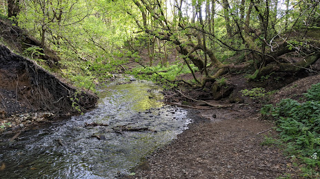
Hopwood Woods — local attraction, which is located at Middleton, Manchester M24 2GN, United Kingdom and belongs to the category — nature preserve. Average visitor rating for this place — 4.5 (according to 181 rating, information from open sources and relevant for 2022).
Exact location — Hopwood Woods, marked on the map with a red marker.
You can get directions to Hopwood Woods on the map from your location.
What else is interesting in Rochdale? You can see all the sights if you go to the city page.
Coordinates
Hopwood Woods, United Kingdom coordinates in decimal format: latitude — 53.56739902200595, longitude — -2.185723474698351. When converted to degrees, minutes, seconds Hopwood Woods has the following coordinates: 53°34′2.64 north latitude and -2°11′8.6 east longitude.
Nearby cities
The largest cities that are located nearby:
- Manchester — 15 km
- Huddersfield — 25 km
- Blackburn — 27 km
- Preston — 40 km
- Sheffield — 52 km
- Rotherham — 56 km
- Liverpool — 59 km
- Stoke-on-Trent — 67 km
- Telford — 105 km
- Sutton Coldfield — 117 km
- West Bromwich — 121 km
- Dudley — 121 km
- Birmingham — 125 km
- Leicester — 127 km
- Coventry — 140 km
- Sunderland — 152 km
- Worcester — 157 km
- Northampton — 174 km
- Cheltenham — 189 km
Distance to the capital
Distance to the capital (London) is about — 268 km.