 Betteshanger
Lynton
Amesbury
Marlow
Burford
Chipping Norton
Marlborough
Cairnryan
Lydney
Betteshanger
Lynton
Amesbury
Marlow
Burford
Chipping Norton
Marlborough
Cairnryan
Lydney
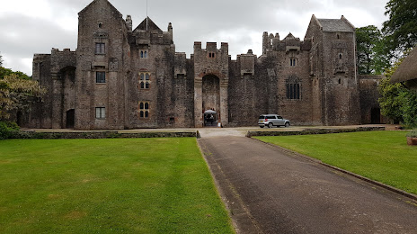
National Trust - Compton Castle on the map, Paignton, United Kingdom
Photo
Where is located National Trust - Compton Castle
National Trust - Compton Castle — local attraction, which is located at Gropers Ln, Compton TQ3 1TA, United Kingdom and belongs to the category — $$. Average visitor rating for this place — 4.1 (according to 345 ratings, information from open sources and relevant for 2022).
Exact location — National Trust - Compton Castle, marked on the map with a red marker.
You can get directions to National Trust - Compton Castle on the map from your location.
What else is interesting in Paignton? You can see all the sights if you go to the city page.
Coordinates
National Trust - Compton Castle, United Kingdom coordinates in decimal format: latitude — 50.47248873772509, longitude — -3.600365074812963. When converted to degrees, minutes, seconds National Trust - Compton Castle has the following coordinates: 50°28′20.96 north latitude and -3°36′1.31 east longitude.
Nearby cities
The largest cities that are located nearby:
- Exeter — 31 km
- Bournemouth — 122 km
- Bristol — 131 km
- Southampton — 159 km
- Swindon — 174 km
- Portsmouth — 178 km
- Cheltenham — 191 km
- Reading — 211 km
- Worcester — 215 km
- Oxford — 215 km
- Brest
 (France) — 236 km
 - Slough — 236 km
- Crawley — 246 km
- Dudley — 250 km
- Birmingham — 253 km
- West Bromwich — 253 km
- Sutton — 254 km
- Watford — 256 km
- Coventry — 258 km
Distance to the capital
Distance to the capital (London) is about — 269 km.