 Betteshanger
Lynton
Amesbury
Marlow
Burford
Chipping Norton
Marlborough
Cairnryan
Lydney
Betteshanger
Lynton
Amesbury
Marlow
Burford
Chipping Norton
Marlborough
Cairnryan
Lydney
Inverugie Castle on the map, Peterhead, United Kingdom
Photo
Where is located Inverugie Castle
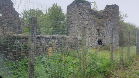
Inverugie Castle — local attraction, which is located at Unnamed Road, Peterhead AB42 3DN, United Kingdom and belongs to the category — castle. Average visitor rating for this place — 4.3 (according to 16 ratings, information from open sources and relevant for 2022).
Exact location — Inverugie Castle, marked on the map with a red marker.
You can get directions to Inverugie Castle on the map from your location.
What else is interesting in Peterhead? You can see all the sights if you go to the city page.
Coordinates
Inverugie Castle, United Kingdom coordinates in decimal format: latitude — 57.524708177592245, longitude — -1.8311435745450915. When converted to degrees, minutes, seconds Inverugie Castle has the following coordinates: 57°31′28.95 north latitude and -1°49′52.12 east longitude.
Nearby cities
The largest cities that are located nearby:
- Edinburgh — 193 km
- Glasgow — 238 km
- Sunderland — 289 km
- Belfast — 417 km
- Blackburn — 418 km
- Preston — 418 km
- Huddersfield — 427 km
- Manchester — 446 km
- Rotherham — 451 km
- Sheffield — 457 km
- Stavanger
 (Norway) — 458 km
 - Liverpool — 460 km
- Stoke-on-Trent — 499 km
- Bergen (Norway) — 502 km
- Telford — 536 km
- Leicester — 540 km
- Sutton Coldfield — 546 km
- Dublin
 (Ireland) — 546 km
 - West Bromwich — 552 km
Distance to the capital
Distance to the capital (London) is about — 678 km.