 Betteshanger
Lynton
Amesbury
Marlow
Burford
Chipping Norton
Marlborough
Cairnryan
Lydney
Betteshanger
Lynton
Amesbury
Marlow
Burford
Chipping Norton
Marlborough
Cairnryan
Lydney
Mexico Towans Beach on the map, Camborne, United Kingdom
Photo
Where is located Mexico Towans Beach
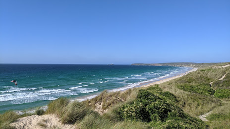
Mexico Towans Beach — local attraction, which is located at no data and belongs to the category — -. Average visitor rating for this place — 4.8 (according to 82 ratings, information from open sources and relevant for 2022).
Exact location — Mexico Towans Beach, marked on the map with a red marker.
You can get directions to Mexico Towans Beach on the map from your location.
What else is interesting in Camborne? You can see all the sights if you go to the city page.
Coordinates
Mexico Towans Beach, United Kingdom coordinates in decimal format: latitude — 50.2066905848507, longitude — -5.4154319940317865. When converted to degrees, minutes, seconds Mexico Towans Beach has the following coordinates: 50°12′24.09 north latitude and -5°24′55.56 east longitude.
Nearby cities
The largest cities that are located nearby:
- Exeter — 135 km
- Brest
 (France) — 210 km
 - Bristol — 232 km
- Bournemouth — 245 km
- Southampton — 282 km
- Swindon — 284 km
- Cork
 (Ireland) — 287 km
 - Cheltenham — 288 km
- Portsmouth — 301 km
- Worcester — 302 km
- Oxford — 325 km
- Reading — 328 km
- Telford — 333 km
- Dudley — 334 km
- West Bromwich — 338 km
- Birmingham — 340 km
- Sutton Coldfield — 350 km
- Coventry — 352 km
- Dublin (Ireland) — 353 km
Distance to the capital
Distance to the capital (London) is about — 398 km.