 Betteshanger
Lynton
Amesbury
Marlow
Burford
Chipping Norton
Marlborough
Cairnryan
Lydney
Betteshanger
Lynton
Amesbury
Marlow
Burford
Chipping Norton
Marlborough
Cairnryan
Lydney
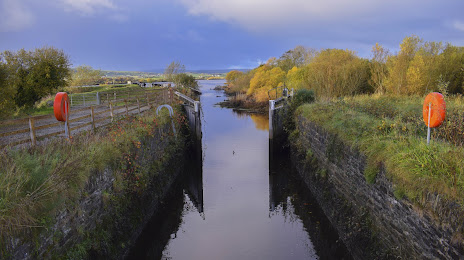
Strabane Canal on the map, Strabane, United Kingdom
Photo
Where is located Strabane Canal
Strabane Canal — local attraction, which is located at Ulster and belongs to the category — -. Average visitor rating for this place — 4.5 (according to 18 ratings, information from open sources and relevant for 2022).
Exact location — Strabane Canal, marked on the map with a red marker.
You can get directions to Strabane Canal on the map from your location.
What else is interesting in Strabane? You can see all the sights if you go to the city page.
Coordinates
Strabane Canal, United Kingdom coordinates in decimal format: latitude — 54.860640403454134, longitude — -7.449655562282229. When converted to degrees, minutes, seconds Strabane Canal has the following coordinates: 54°51′38.31 north latitude and -7°26′58.76 east longitude.
Nearby cities
The largest cities that are located nearby:
- Belfast — 101 km
- Dublin
 (Ireland) — 182 km
 - Glasgow — 230 km
- Edinburgh — 292 km
- Cork (Ireland) — 331 km
- Preston — 333 km
- Liverpool — 334 km
- Blackburn — 347 km
- Manchester — 374 km
- Sunderland — 387 km
- Huddersfield — 394 km
- Stoke-on-Trent — 405 km
- Telford — 412 km
- Sheffield — 426 km
- Rotherham — 430 km
- Dudley — 443 km
- West Bromwich — 448 km
- Sutton Coldfield — 454 km
- Birmingham — 456 km
Distance to the capital
Distance to the capital (London) is about — 614 km.