
 Maureville
Samoëns
Gréning
Toulouse
Volx
Goudet
Méhoncourt
Saint-Hymer
Pontcarré
Maureville
Samoëns
Gréning
Toulouse
Volx
Goudet
Méhoncourt
Saint-Hymer
Pontcarré
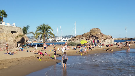
Beach of Raguette (Plage de la Raguette) on the map, Cannes, France
Photo
Where is located Beach of Raguette (Plage de la Raguette)
Beach of Raguette (Plage de la Raguette) — local attraction, which is located at no data and belongs to the category — -. Average visitor rating for this place — 4.3 (according to 1140 ratings, information from open sources and relevant for 2022).
Exact location — Beach of Raguette (Plage de la Raguette), marked on the map with a red marker.
You can get directions to Beach of Raguette (Plage de la Raguette) on the map from your location.
What else is interesting in Cannes? You can see all the sights if you go to the city page.
Coordinates
Beach of Raguette (Plage de la Raguette), France coordinates in decimal format: latitude — 43.53094813713307, longitude — 6.978290354151432. When converted to degrees, minutes, seconds Beach of Raguette (Plage de la Raguette) has the following coordinates: 43°31′51.41 north latitude and 6°58′41.85 east longitude.
Nearby cities
The largest cities that are located nearby:
- Nice — 26 km
- Toulon — 100 km
- Aix-en-Provence — 126 km
- Marseille — 136 km
- Turin
 (Italy) — 176 km
 - Genoa (Italy) — 179 km
- Grenoble — 207 km
- Nimes — 214 km
- Novara (Italy) — 244 km
- Montpellier — 252 km
- Livorno (Italy) — 264 km
- Milan (Italy) — 270 km
- Monza (Italy) — 285 km
- Saint-Étienne — 292 km
- Parma (Italy) — 294 km
- Villeurbanne — 295 km
- Lyon — 297 km
- Geneva
 (Switzerland) — 300 km
 - Bergamo (Italy) — 314 km
Distance to the capital
Distance to the capital (Paris) is about — 691 km.