 Maureville
Samoëns
Gréning
Toulouse
Volx
Goudet
Méhoncourt
Saint-Hymer
Pontcarré
Maureville
Samoëns
Gréning
Toulouse
Volx
Goudet
Méhoncourt
Saint-Hymer
Pontcarré
Plage Port-au-Loup on the map, Guérande, France
Photo
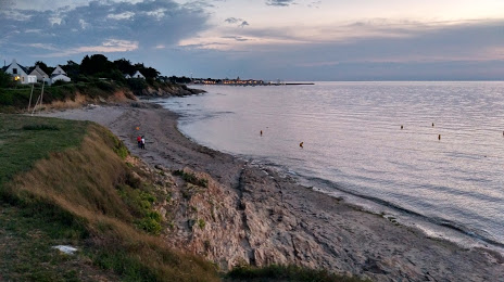
Where is located Plage Port-au-Loup
Plage Port-au-Loup — local attraction, which is located at no data and belongs to the category — -. Average visitor rating for this place — 4.2 (according to 216 ratings, information from open sources and relevant for 2022).
Exact location — Plage Port-au-Loup, marked on the map with a red marker.
You can get directions to Plage Port-au-Loup on the map from your location.
What else is interesting in Guérande? You can see all the sights if you go to the city page.
Coordinates
Plage Port-au-Loup, France coordinates in decimal format: latitude — 47.388150014782596, longitude — -2.5287546166427712. When converted to degrees, minutes, seconds Plage Port-au-Loup has the following coordinates: 47°23′17.34 north latitude and -2°31′43.52 east longitude.
Nearby cities
The largest cities that are located nearby:
- Nantes — 67 km
- Rennes — 103 km
- Angers — 140 km
- Brest — 191 km
- Le Mans — 208 km
- Tours — 233 km
- Caen — 253 km
- Le Havre — 301 km
- Bordeaux — 311 km
- Orléans — 328 km
- Limoges — 329 km
- Rouen — 345 km
- Bournemouth
 (United Kingdom) — 377 km
 - Boulogne-Billancourt — 379 km
- Exeter (United Kingdom) — 383 km
- Portsmouth (United Kingdom) — 397 km
- Southampton (United Kingdom) — 402 km
- Eastbourne (United Kingdom) — 425 km
- Amiens — 440 km
Distance to the capital
Distance to the capital (Paris) is about — 397 km.