Columbus — Armada
Columbus — Concord
Columbus — Jacksboro
Columbus — Perkins County
Columbus — Atkinson
Columbus — McCarthy
Columbus — Sagle
Columbus — Louisville
Columbus — Boyne City
Columbus — Moxahala
Columbus — Napoli
Columbus — Petrolia
Columbus — Butte des Morts
Columbus — Custer
Columbus — Carrollton
Columbus — Comfort
Columbus — High Rolls
Columbus — Bucks
Columbus — Gap Mills
Edinburgh
Mount Auburn
Greenwood
Greenwood
Beech Grove
Indianapolis
Indianapolis
Zionsville
Whitestown
Lebanon
Thorntown
Frankfort Municipal Airport
Fickle
Stockwell
Tippecanoe County
Lafayette
Brookston
Rensselaer
Roselawn
Crown Point
Merrillville
Hobart
Gary
East Chicago
Hammond
Calumet City
Burnham
Cook County
Chicago
Chicago
Chicago
Niles
Park Ridge
Rosemont
Des Plaines
Mount Prospect
Schaumburg
Rolling Meadows
Palatine
Kildeer
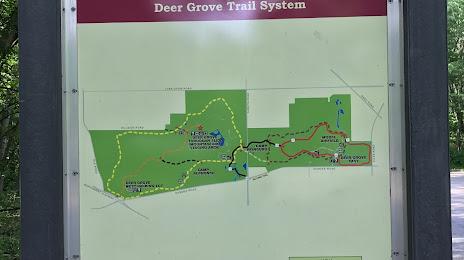
Columbus — Lake Zurich distance, route on the map
Distance by car
Distance between Columbus, Indiana, United States and Lake Zurich, Illinois, United States by car is — km, or miles. To travel this distance by car, you need minute, or h.
Route on the map, driving directions
Car route Columbus — Lake Zurich was created automatically. The road on the map is shown as a blue line. By moving the markers, you can create a new route through the points you need.
Passing cities through which the car route passes: Northcliff, Edinburgh, Mount Auburn, Greenwood, Greenwood, Beech Grove, Indianapolis, Indianapolis, Zionsville, Whitestown, Lebanon, Thorntown, Frankfort Municipal Airport, Fickle, Stockwell, Tippecanoe County, Lafayette, Brookston, Rensselaer, Roselawn, Crown Point, Merrillville, Hobart, Gary, East Chicago, Hammond, Calumet City, Burnham, Cook County, Chicago, Chicago, Chicago, Niles, Park Ridge, Rosemont, Des Plaines, Mount Prospect, Schaumburg, Rolling Meadows, Palatine, Kildeer.
Distance by plane
If you decide to take a trip Columbus Lake Zurich by plane, then you have to fly the distance — 380 km or 236 miles. It is marked on the map with a gray line (between two points in a straight line).
Flight time
Estimated flight time Columbus Lake Zurich by plane at cruising speed 750 km / h will be — 30 min.
Direction of movement
United States, Columbus — right-hand traffic. United States, Lake Zurich — right-hand traffic.
Difference in time
Columbus and Lake Zurich are in different time zones. The time difference is 1 hour (UTC -4 America/New_York, UTC -5 America/Chicago).
Interesting Facts
Information on alternative ways to get to your destination.
The length of this distance is about 0.9% of the total length of the equator.
The percentage of the population is clearly shown in the graph:
Columbus — 44,061, Lake Zurich — 19,903 residents (less by 24,158).
The cost of travel
Calculate the cost of the trip yourself using the fuel consumption calculator, changing the data in the table.