
 Mikhaylovka
Dyrestuy
Mikhaylovka
Mayskiy
Novobessergenevka
Tersky District
Lesnoy
Tertezh
Kuz'minskiye Otverzhki
Mikhaylovka
Dyrestuy
Mikhaylovka
Mayskiy
Novobessergenevka
Tersky District
Lesnoy
Tertezh
Kuz'minskiye Otverzhki
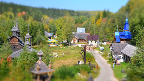
Ethnographic Park Chusovaya river history on the map, Chusovoy, Russian Federation
Photo
Where is located Ethnographic Park Chusovaya river history
Ethnographic Park Chusovaya river history — local attraction, which is located at ул. Ударника, 30, Chusovskoye Urban Settlement, Perm Krai, 618200 and belongs to the category — park. Average visitor rating for this place — 4.8 (according to 542 ratings, information from open sources and relevant for 2022).
Exact location — Ethnographic Park Chusovaya river history, marked on the map with a red marker.
You can get directions to Ethnographic Park Chusovaya river history on the map from your location.
What else is interesting in Chusovoy? You can see all the sights if you go to the city page.
Coordinates
Ethnographic Park Chusovaya river history, Russian Federation coordinates in decimal format: latitude — 58.312189521850975, longitude — 57.85709579855634. When converted to degrees, minutes, seconds Ethnographic Park Chusovaya river history has the following coordinates: 58°18′43.88 north latitude and 57°51′25.54 east longitude.
Nearby cities
The largest cities that are located nearby:
- Perm — 93 km
- Berezniki — 138 km
- Solikamsk — 162 km
- Pervouralsk — 198 km
- Yekaterinburg — 232 km
- Glazov — 301 km
- Sarapul — 317 km
- Izhevsk — 323 km
- Neftekamsk — 325 km
- Zlatoust — 364 km
- Miass — 391 km
- Ufa — 409 km
- Chelyabinsk — 414 km
- Kirov — 471 km
- Nizhnekamsk — 476 km
- Tyumen — 478 km
- Almetyevsk — 513 km
- Syktyvkar — 525 km
- Sterlitamak — 528 km
Distance to the capital
Distance to the capital (Moscow) is about — 1252 km.