
 Mikhaylovka
Dyrestuy
Mikhaylovka
Mayskiy
Novobessergenevka
Tersky District
Lesnoy
Tertezh
Kuz'minskiye Otverzhki
Mikhaylovka
Dyrestuy
Mikhaylovka
Mayskiy
Novobessergenevka
Tersky District
Lesnoy
Tertezh
Kuz'minskiye Otverzhki
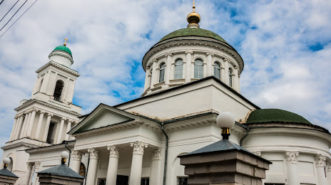
Okovetskiy Sobor on the map, Rzhev, Russian Federation
Photo
Where is located Okovetskiy Sobor
Okovetskiy Sobor — local attraction, which is located at Ulitsa Marata, 5, Rzhev, Tver Oblast, 172381 and belongs to the category — russian orthodox church. Average visitor rating for this place — 4.9 (according to 54 ratings, information from open sources and relevant for 2022).
Exact location — Okovetskiy Sobor, marked on the map with a red marker.
You can get directions to Okovetskiy Sobor on the map from your location.
What else is interesting in Rzhev? You can see all the sights if you go to the city page.
Coordinates
Okovetskiy Sobor, Russian Federation coordinates in decimal format: latitude — 56.25518103660283, longitude — 34.33647799847508. When converted to degrees, minutes, seconds Okovetskiy Sobor has the following coordinates: 56°15′18.65 north latitude and 34°20′11.32 east longitude.
Nearby cities
The largest cities that are located nearby:
- Tver — 117 km
- Zelenograd — 179 km
- Obninsk — 191 km
- Odintsovo — 195 km
- Khimki — 197 km
- Smolensk — 218 km
- Pushkino — 219 km
- Izmaylovo — 221 km
- Podolsk — 222 km
- Kaluga — 227 km
- Balashikha — 231 km
- Lyubertsy — 231 km
- Velikiye Luki — 233 km
- Serpukhov — 246 km
- Noginsk — 260 km
- Elektrostal — 263 km
- Orekhovo-Zuyevo — 293 km
- Kolomna — 309 km
- Tula — 311 km
Distance to the capital
Distance to the capital (Moscow) is about — 211 km.